| My pages about the area around Central part of Sweden |

Färnebofjärden is a National Park that protects a stretch of the Lower Dalälven River running from the city of Avesta to the Bothnian Sea. Water is the main feature of this park and water is what you will see here. Flooded areas, wetlands, streams and lakes, and of course wildlife, birds, forests and flowers.
But mainly water.......... a beautiful sight to see, but it makes the area rather hard to access. The best way to enjoy Färnebofjärden would probably be by boat (which you can rent in the area), or by hiking on the edges of the park.
Färnebofjärden is another of Swedens wonderful National Parks. I think I love all the National Parks, some just a bit more then others. Färnebofjärden is certainly not on the top of my list, as the access to the park isn't so easy, making it a bit harder to enjoy. But the memories of this wonderful evening will always stay, so I guess the park did manage to capture a place in my heart.
Färnebofjärden

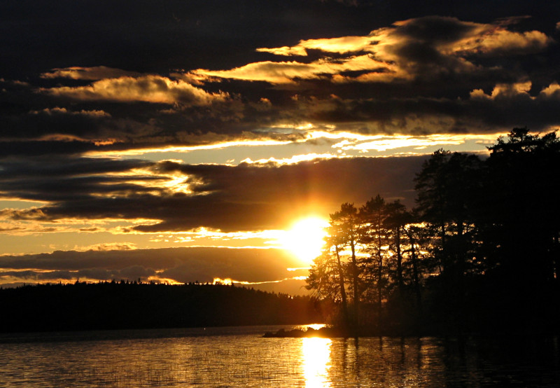
I arrived late afternoon at the park, very early in the season, with no people around yet. We were allowed to put up our little tent on the beach (an advantage of travelling off season), from where we had the most beautiful views over the waters of the Dalälven and Färnebofjärden National Park. The sun was going down, turning the sky into a work of art, but there was still enough light and time for a short walk along the shores.
While walking on the beach we could see a deer quickly making its way over one of the wetlands, we heard the cry of a bird in the distance and the sound of a woodpecker in the tree above. The water was washing gently up the shore, the glittering of the sun in the water, a soft breeze, and the wonderful sound of 'silence'. This is how I remember Färnebofjärden, and how I liked it at its best.

Setting up camp on the beach


Färnebofjärden is all about aquatic landcape: the park covers 100 square kilometers, of which around 40% (41 square kilometers) is aquatic. It is a floodplain of the river "Nedre Dalälven" and there are more than 200 islands, islets and skerries here.
An interesting fact is that the natural border between the environments of the northern part of Sweden and the south is at the park. This border is called the "limes norrlandicus" (named by the famous Swedish botanist Carl Linneaus).
And this has created an interesting biosphere where species of both the flora and the fauna from north and south meet. The western part of the national park contains mires and coniferous forests of a northern character. Down the river the landscape is more lush, with old deciduous trees like oak and lime.

The name "Färnebofjärden" always intrigued me, and have always wondered where the name comes from. So I tried to dissect this name:
• Simply put the name means "fjärd of Färnebo".
• The Swedish word fjärd has the same etymology as the Norwegian word fjord, both of these words mean "an expanse of water in a channel" / "a large open space of water between groups of islands or mainland in archipelagos"
• The name Fjärnebo is the ancient name of the village near to the park.
• But you can dissect the name of the village even more:
• The name of the village means: habitation ("bo") next to the fjärd of horsetails ("Fjärne"). The plantname "fräken" in Swedish (which became the word "Färne") is in english the plant "Horsetails". See photo to the right.
• So simply put "Färnebofjärden" means something like:
A habitat near to an expanse of water, where the Horsetails grow :-)


It turned out that we had the beach location all to ourselves, and we enjoyed a lazy morning on the beach, taking in the views and the sounds of Färnebofjärden.
But one cannot be lazy all the time, so it was time to discover a bit more of the park and do one of the shorter hikes through the forest and more bog-like areas of the national park.
So time to pack up the tent, and do some exploring, before returning home!


Gysinge

Before we drove home we took a quick stop at Gysinge, located just outside of the National Park. It's an intresting place to visit as you can still see the historic buildings att Gysinge Bruk.
Gysinge was founded in 1668, during the development of the iron mining industri. The forests around were exploited to feed the water-powered forges, and Gysinge was one of the most important forges in the area.


Simone & Åke, Färnebofjärden, Sweden, June 2006
I do love visiting National Parks, and I've visited quite a few of them so far in Sweden. Hopefully some day I will have been to all of them. Below you can find an overview of all the Swedish National Parks:
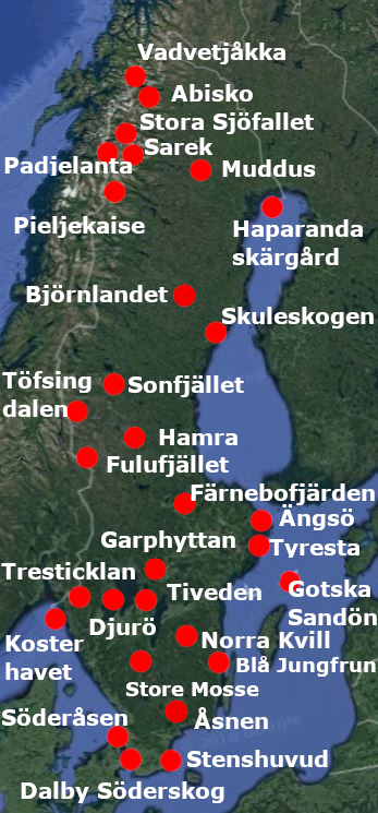
Abisko, (2005, 2009, 2019)
Björnlandet
Blå Jungfrun
Dalby Söderskog
Djurö
Fulufjället, (2003)
Färnebofjärden, (2006)
Garphyttan, (2015)
Gotska Sandön, (2009)
Hamra, (2016)
Haparanda skärgård
Kosterhavet, (2021)
Muddus
Norra Kvill
Padjelanta, (2006, 2017)
Pieljekaise
Sarek, (2008)
Skuleskogen, (2020)
Sonfjället, (2016)
Stenshuvud
Stora Sjöfallet, (2006, 2017)
Store Mosse
Söderåsen
Tiveden, (2004, 2008 ,2018)
Tresticklan, (2021)
Tyresta, (2004, 2020)
Töfsingdalen
Vadvetjäkka
Åsnen
Ängsö, (2006)

It would be great to hear from you!
You can reach me by sending me an Email.
Or leave a comment / reaction in the box below.
You can also follow me on Facebook: Sim1 around the World Blog
:-) Simone