| My pages about Iceland |

September 2020: Who would have thought this would be possible, that we would travel abroad autumn 2020! But we did! We found an opportunity at the very VERY last minute to travel to Iceland! It meant 1 week in quarantine in a nice little house in middle of nowhere, but with great views! And 2 weeks of travelling around the whole island. And being able to travel here during the Covid time has been such a unique opportunity, with hardly anyone around and being able to experience the amazing nature without disturbances.
For now this page will be a sort of photo collage, but hopefully some day soon I will have some time to write a bit more in depth about my visit to Hengifoss.
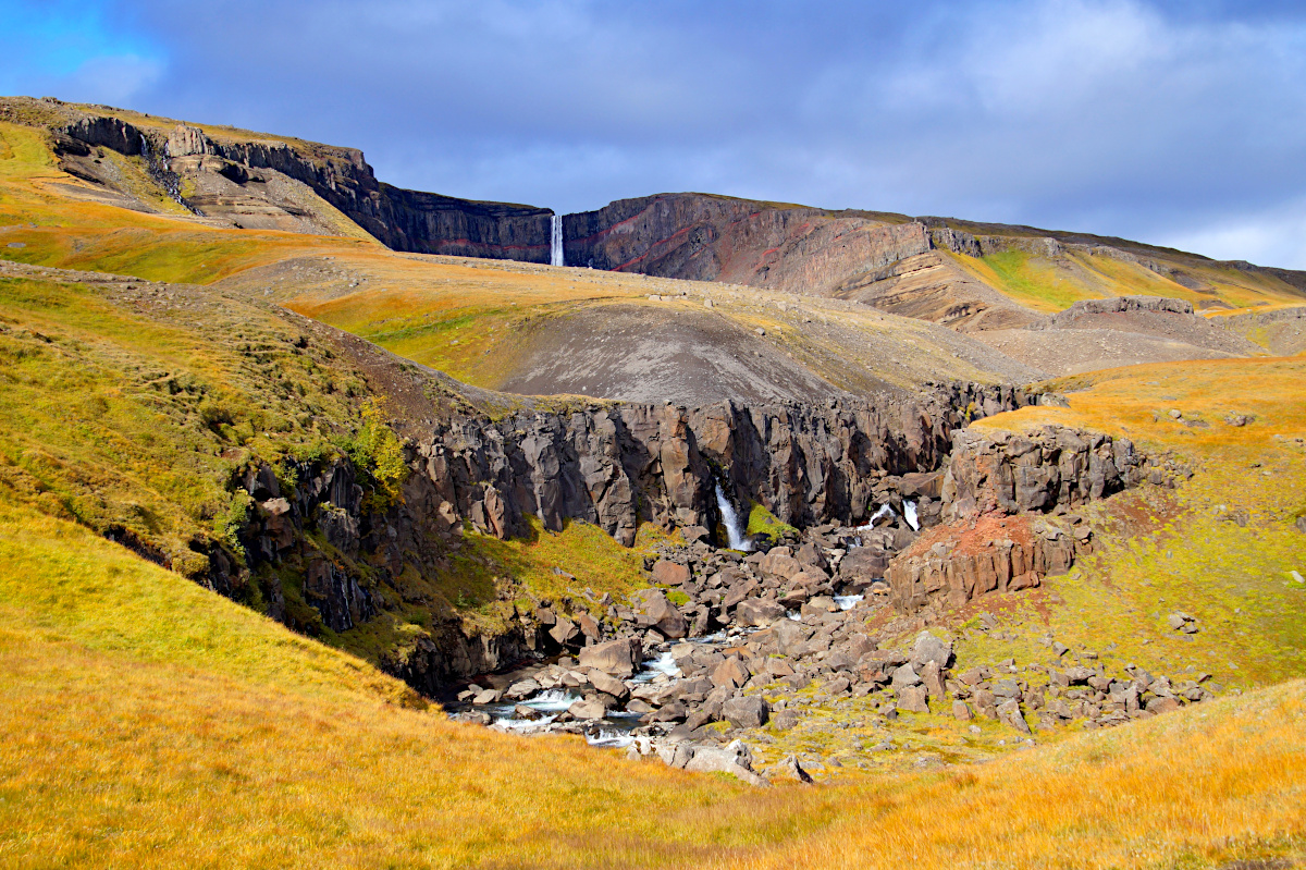
Hengifoss, the red layers waterfall
Iceland
Good morning all! Today we are having a long travel day ahead of us. We are travelling from the south eastern part of Iceland (the town of Höfn) to the Northern part (town of Husavik). But our main focus of today is not travelling from A to B, it is making a stop and hike towards the Hengifoss, a really amazing waterfall! So this morning we are driving the scenic route from Höfn to the Hengifoss, a drive of about 3 hours and 200 kilometers. The majority of the route is on the main road, route 1. But we took the "shortcut" road 95 (note: not passable in the winter).

But before I continue with my impressions of Hengifoss, please let me give you an idea where you can find it on the map. Hengifoss is located in the eastern part of Iceland. It is about 8 hours / 670 kilometres drive east of Reykjavik.
location on the map: 65.07338, -14.88267
Another important thing is to ensure to have a filled gas tank because distances are long here and gas stations are few and far between in this area.
The journey

A giant red chair bolted to a rock on this remote part of Iceland.
We drive through impressive empty landscape that is typical for Iceland, but which never stops to amaze me. Although this is the major road rounding the island, we are quite alone along this strecth of road. There’s nothing around us for miles and miles, just this vast, empty landscape. But all of a sudden we see this surreal unexplainable scene in front of us: a huge red chair is inexplicably bolted to a rock in the middle of nowhere!
We are so baffled by the sight that we just had to make a stop to explore. It feels totally illogical why this oversized chair is placed just here. The bright red colour is in stark contrast against the endless landscape of grey rocks and grey sky that are surrounding us, which makes it fascinating. So no need to say I had to climb up here to see it up close! The views from the chair are not particular logical though as the back of the chair faces the Atlantic Ocean. The chair is a surreal scene, and for me a nice place to stretch the leggs on this long road trip.


Our road hugging the coastline


Hiking to Hengifoss


Time for some hike statistics:
We have an app on our phone that records our walks, which is quite fun (the App is called Komoot). The map on the left side is our recorded walk.
If you want to do the exact same hike as we did, you can find the link here: https://www.komoot.com/tour/259528134
Starting point: If you are driving on the road 1 coming from the south: at Fellabær take the exit left to road 931 (Fljótsdalur). Follow the road for 32 kilometer until you see a parking at the right side of the road. This is the trailhead to Litlanesfoss and Hengifoss.
GPS starting point: GPS 65.073316, -14.880282 (click to open coordinates on google maps)
Type: Return trail
Length: 4,6 km.
Total height difference: 230 m
Highest point: 330 m, Lowest point: 110 m
Trail signs: well marked
Difficulties:Walking upp 230 meters! Otherwise relatively easy. A lot of maintenance had been done on the trail the year before we went here, so it was in good condition with additional easy to hike boardwalk on the more difficult stretches.


The name Hengifoss is translated to the Hanging Waterfall.

basaltic strata with thin, red layers of clay between the basaltic layers
The waterfall is surrounded by basaltic strata with thin, red layers of clay between the basaltic layers. The red stripes are so striking and intriging to see!
These red layers are made of clay separating hardened basalt from various volcanic eruptions. These eruptions took place during the Tertiary Period, when the island of Iceland was first being formed. But vulcano eruptions are rarely continuous and during these 'inbetween' periods, the ash was able to settle on top the smoldering layers of lava. If the breaks in the eruptions are long enough and the conditions just right, the ashes, through the addition of clay and iron minerals, slowly turn into soil.
When new eruptions occur, and the additional lava are layered over the top of these ash-rich soils, a chemical reaction takes place. The iron trapped within the soil reacts with the oxygen transported by the lava, and they together form iron oxide. In short, the soils rusts! And this rust creates these striking red layers. As the process is repeated time and time again, layers of alternating black lava and red soils are built up to form this mesmerizing layered effect.


Simone & Åke, September 2020, Hengifoss, Iceland

It would be great to hear from you!
You can reach me by sending me an Email.
Or leave a comment / reaction in the box below.
You can also follow me on Facebook: Sim1 around the World Blog
:-) Simone