| My pages about the northern part of Sweden |
| My travel stories | My photo impressions | ||
| Rádunjárga | Katterjåkk to Stuor-Kärpel | Abisko | |
| Alesjaure | Sarek | ||
| Unna Allakas | |||
| Kvikkjokk to Njunjes | |||
| Njunjes to Tarrekaise | |||
| Tarrekaise to Sommarlappa | |||
| Sommarlappa to Tarraluoppal |

I love the very north of Sweden. This is the mountain area called "Fjällen" and home to some of Swedens most amazing National Parks (Abisko, Padjelanta, Sarek and Stora Sjöfallet). Endless areas of wilderness, perfect for making multi-day hikes.
This is a long time dream coming true, visiting this amazing national park and hiking almost 2 weeks in this fantastic place!
Padjelanta Hiking Tour 2006
Part 4: Sommarlappa to Tarraluoppal
Sunday morning, the 23rd of July
Early mornings always seem to be the most difficult part of the day in the Fjällen for me. Inside the tent is relatively warm and cosy, especially inside the super comfortable and warm sleeping bags, but outside, brrrr, I know it is cold! With temperatures dipping to around zero Celsius at night, and only slightly above during the early morning hours, I always seem to find it hard to get up and moving. But as usual after a (long) while I gather enough energy and courage to do so.
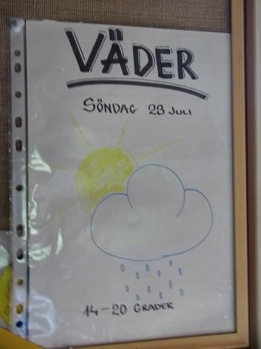
I quickly run from the tent towards the mountain hut of Såmmarlappa which is about 50 to a 100 metres away (don't really know, hahaha, but it feels forever when running towards it in the rain, lol). There is a drizzle of rain outside, and I feel a bit worried and dubious what today's weather is going to bring. Inside the mountain hut it is cosy and warm, and not only warm in temperature, also warm in feeling, as it is so welcoming to go in here. The kettle is already on for a cup of tea, and a sunny smile is greeting us from the weather chart. A mixture of weather it promises us on this early Sunday morning, the 23rd of July, with some rain and temperatures ranging from 14C to 20C. But the part that catches my attention the most is the nice bright yellow happy sunshine peaking out from the clouds.

It seems like the weather prediction is not that far off, with a mixture of rain and clouds and temperatures around the 15C. The sky seems to be playing a game with us today though, one moment a drizzle of rain, slowly changing into a flow of thicker rain drops. Sigh, letsput on the rain gear again..... By the time I completed the struggle of taking off my backpack, finding my rain clothes and putting them on, the sky dries up again, and leaves me standing there in the middle of nowhere feeling totally frustrated. Okay, let's try it one more time without the rain pants..... mutter... mutter...
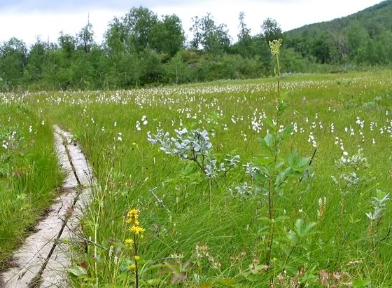
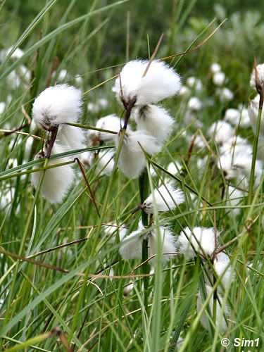
I don't like to wear full rain gear for a long time if it is not necessary, so I try to bear with the weather as long as possible. The landscape isn't so bad though for doing this fashion show, as it is beautiful out here! The drizzle of rain stopped once again, and we arrived in this lovely meadow filled with a flower called Polarull in Swedish, or the Eriophorum scheuchzeri Hoppe in Latin or Scheuchzer's Cottongrass in English. This flower is not a stranger to this area, in fact it is quite common in the whole Fjällen area and Padjelanta National Park is no exception to this rule. This grassy plant, which looks so cute because of it little fluffy wool-like top, reaches a height of 10-30 cm and can be seen in bloom during the month of July.
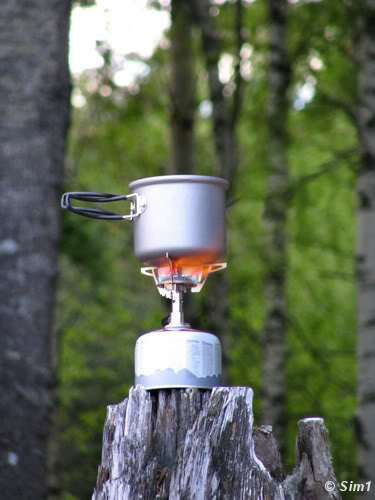
Once again the trail leads through a forest of birches, leaving not that much chances for a nice place to stop along the way. But no worries, there is a perfect spot for a short break or picnic when you arrive at the river at Slihtavagge. It is roughly about 4 to 5 kilometres from Såmmarlappa to get to the river, so perfect timing for all those that are by now craving for a hot cup of coffee or a hearty bowl of soup. Be clever though, make the soup at the mountain hut of såmmarlappa and bring it with you in a thermos. This will save you time and energy during your hike, especially when the weather is not that good. The hot soup will warm you up and give you some well needed new energy on a cold and drizzly day.
We were in luck though, as ones again, the drizzle of rain had stopped and even the clouds were slightly threatening to get out of the way and show us some sun. So we dropped down on an improvised bench, enjoying our soup and listen to the thundering noise of the river in front of us. The only way to cross this river is by a bridge and a sturdy one in this case as well. After that the trail goes up a bit, and then...... according to the map, there should be the entrance to Padjelanta National Park! It took us three hiking days to get here, but finally we arrived at the National Park we both have been longing so much to see.....
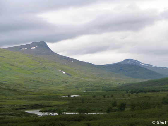
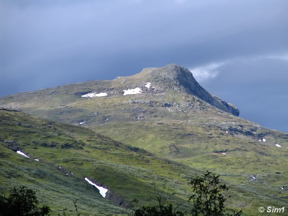
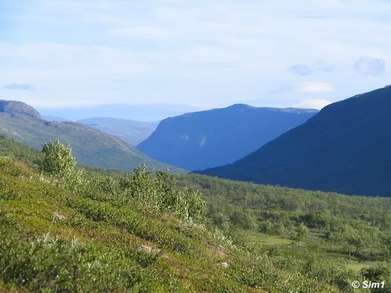
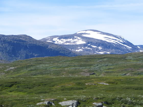
It is only a short steep climb up from the river at Slihtavagge and then all of a sudden the landscape opens up. Before your eyes is the immense landscape of Padjelanta National Park. The sudden change in landscape is so very shocking, from endless days in the forest to, without any forewarning, this wide open valley and views as far as the eyes can reach. The photos don't do this landscape justice; no they are not even close to showing its true beauty. But it is engraved in my mind and heart and I wish I could share this moment with you somehow.
While I write down these memories I get goose bumps again and tears cloud my eyes. Yes, these are the exact same feelings I had when standing there, at the entrance of Padjelanta. The only thing not present now is the pounding heart and heavy breathing, while trying to catch my breath after the short steep climb. I wonder how my face must have looked, probably stunned, and in awe at the same time. I remember not being able to utter words for a few minutes as the landscape totally absorbed my mind and emotions. Yes, we are finally here, at Padjelanta, and yes, this is only the very beginning of what Padjelanta has to offer.....
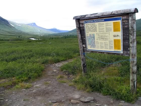
In the rest of this page and also the following pages you can read more about my experience in Padjelanta and the beauty this national park offers. But maybe now, while standing at its entrance and at the welcome sign to the park, it is a good time to give you a short intro to the park.
Padjelanta, or in the Sami language called Bádjelándda, means the "high land" which is an appropriate name, as almost the whole national park is located above the tree line. It is Sweden's largest National Park with an amazing 1,984 km2 in size. But the park is not on its own, it is surrounded by nature reserves (as was the area I hiked through so far). It is also connected to two other amazing national parks called Sarek and Stora Sjöfallet. Padjelanta is also part of an even larger area called Laponia, which is sometimes referred to as the "last wilderness of Europe".
There are no roads that lead to Padjelanta, only this hiking trail. No cars in sight, not even close. If you want to see this, you need to walk. The only way to get here is by foot, or, if you like, helicopter in to the Sami village of Staloluokta. But from there you have to make your way again on foot. The landscape is wonderful, large lakes, open mountain landscape and exceptionally varied flora and fauna. If you are lucky you might catch a glimpse of a snowy owl, arctic fox or wolverine. But without a doubt you will meet some reindeer, as Padjelanta is a valuable grazing land for reindeers. And with the reindeer come three tiny Sami villages, which are all located very isolated in this beautiful highland area. Padjelanta is a special place, but at the same time not demanding. The only way to get here is on foot, but everyone that is in a reasonable condition can make that walk. In short: Padjelanta is a place to fall in love with..... just as I did.
Although the landscape opened dramatically in front of us when entering Padjelanta, we are not really 'out of the woods' yet. For once again we dive into the woods on a winding path that seems to go on forever. It does feel more like wilderness here as the trail isn't that easy to walk. I am manoeuvring left and right to avoid branches hanging over the trail, whilst we are climbing up and down, not knowing where the path is going to lead. The dense growth of small trees is blocking all the views and we have no clue how far we have to go.
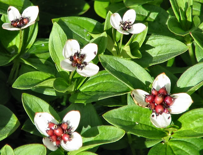
The map indicates that we have to walk quite a bit through this overgrown area, but we have lost track of time and distance and start to wonder how far this 'far' is going to be. While we stare at the map and try to locate our position, the little flowers of the Dwarf Cornel (bunchberry), smile at us from the ground. They seem to thrive here in this forested area, whilst enjoying the warmth of the afternoon sun. A smile appears on my face, let's brighten up, it really can't be that far anymore!
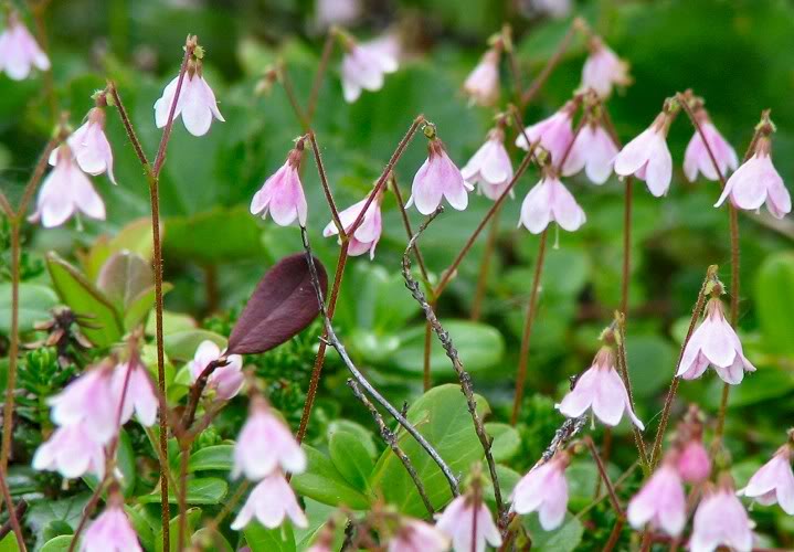
Another flower that seems to enjoy the live in this part of the world is the twinflower, named so after the two delicate twin like flowers. I really like this little flower, which is so easily overlooked. The plant is small and delicate, but so elegant at the same time. The leafs are low to the ground, oval in shape and the two little flowers are in a pale pink colour, dangling down from the top of a slender stem.
The scientific name of the flower is maybe even more special as this flower is called the "Linnaea borealis", and maybe that might ring a bell to some of you. The flower is one of the few species named after the famous Swedish botanist Carolus Linnaeus, also known (after his ennoblement) as Carl von Linné. Carl von Linné is often called the "Father of Taxonomy". His system for naming, ranking, and classifying organisms is still in wide use today.
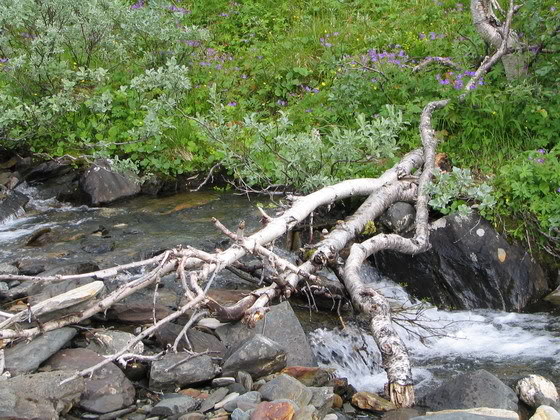
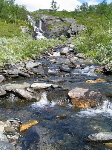
This part of the hike is probably the most challenging of the entire Padjelantaleden, as we now start to cross numerous creeks and little rivers. With every creek we pass the crossing seems to get a bit more challenging. There are no bridges here, so alternative routes are the way to go! Our eyes search over the river for the best place to cross. Sometimes the route is easy as pieces of wood are in place, and with a bit of a balancing act, we are able to cross the creek while keeping our feet dry. Others are more challenging, and we try to find the most logical and easy way to jump from one boulder to another. And yes, another successful crossing is made! Depending on the time of year, and thus the amount of melting water and/or rain, these rivers and creeks can get easier or far more difficult to cross. But luck is on our side, and we crossed them all without any major problems.
By now we are making some real progress in the hike and the trees have almost disappeared and are replaced by a dense growth of shrubs. Soon we will be 'out of the woods' and be able to see the beautiful open mountain landscape again. In total the hike from Såmmarlappa towards the end of the wooded area is about 9 or 10 kilometres. In the last kilometre we see a lot of open spots in between the shrubs, which look like suitable places to put up a tent. But don't! Although the fresh water provided by the rivers is tempting, and the protection from the wind because of the shrubs looks appealing as well, there is a far better spot, only a tiny bit further on on the trail, away from the mosquitoes and with a view to die for.....
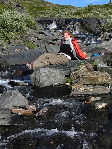
This might sound like a nightmare to some, but it is a dream to me. It was so perfect sitting lazy on this big slab of rock in the middle of the river, no one around for miles and miles, no sounds to be heard, except the one of the birds singing in the distance and the sound of rushing water at my feet. The sun is shining happily on my face, and I have this pink-red feeling on the cheeks because of cool breeze of mountain air. Yes, it isn't warm, so dressing in several layers is a must. But with the right clothing the weather isn't a problem at all.
Hahaha, which reminds me of a saying that the Sweden live by and truly believe in:
"There is no bad weather, there is only bad clothing"
Well, I don't agree with "them" a 100% of the time, because there IS bad weather. But weather like this could hardly be called bad. I could have sat here for hours and hours with my hot cup of fresh tea in my hand. But of course I didn't.... it's time to look around the area a bit before the evening falls....
About one kilometre, or maybe even less, we arrive at another river a bit wider this one, but at a beautiful location. We are tired, in the body and the mind, but so happy in the soul. Despite the demanding hike, we feel so good. The sun is showing its face and the landscape is stunning. It doesn't take us long to decide, this is 'the place'!!!
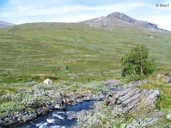
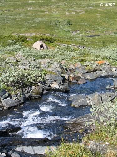
We drop off our backpacks and start exploring the area for a good spot to put up the tent. Too close to the river the soil is too wet... not good. The terrain is slightly hilly, or at least not level.... not good either. But then, we see it. A nice level spot, hidden behind a little bump in the landscape, giving some protection from the wind, and close to the river, which is our supply for fresh water.... yes, this is good!! Like little children we run back to the trail where we dumped our backpacks and start dragging them down into the valley below. Within minutes the tent is up and it looks perfect. Yes, this is 'the place'! A dream spot to camp, beside this little river without a name.
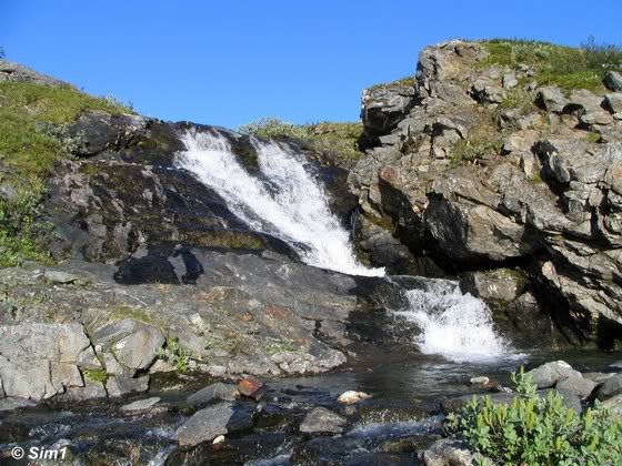
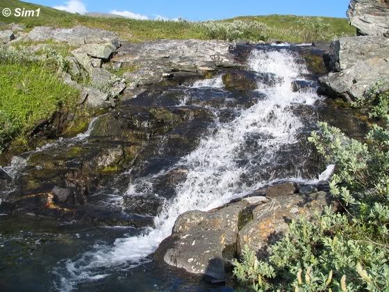
In the first photo you can see our tent, a little dot in an endless landscape. Far below is the big river Taraätno, not visible from here, which named this valley called the Tarradalen. The other photos are some evening shots taken of the surroundings.
So what do you do after a long day of hiking to relax when you are camping in the middle of nowhere far far away from the civilized world??? Well, walk a little bit more of course! ;-)
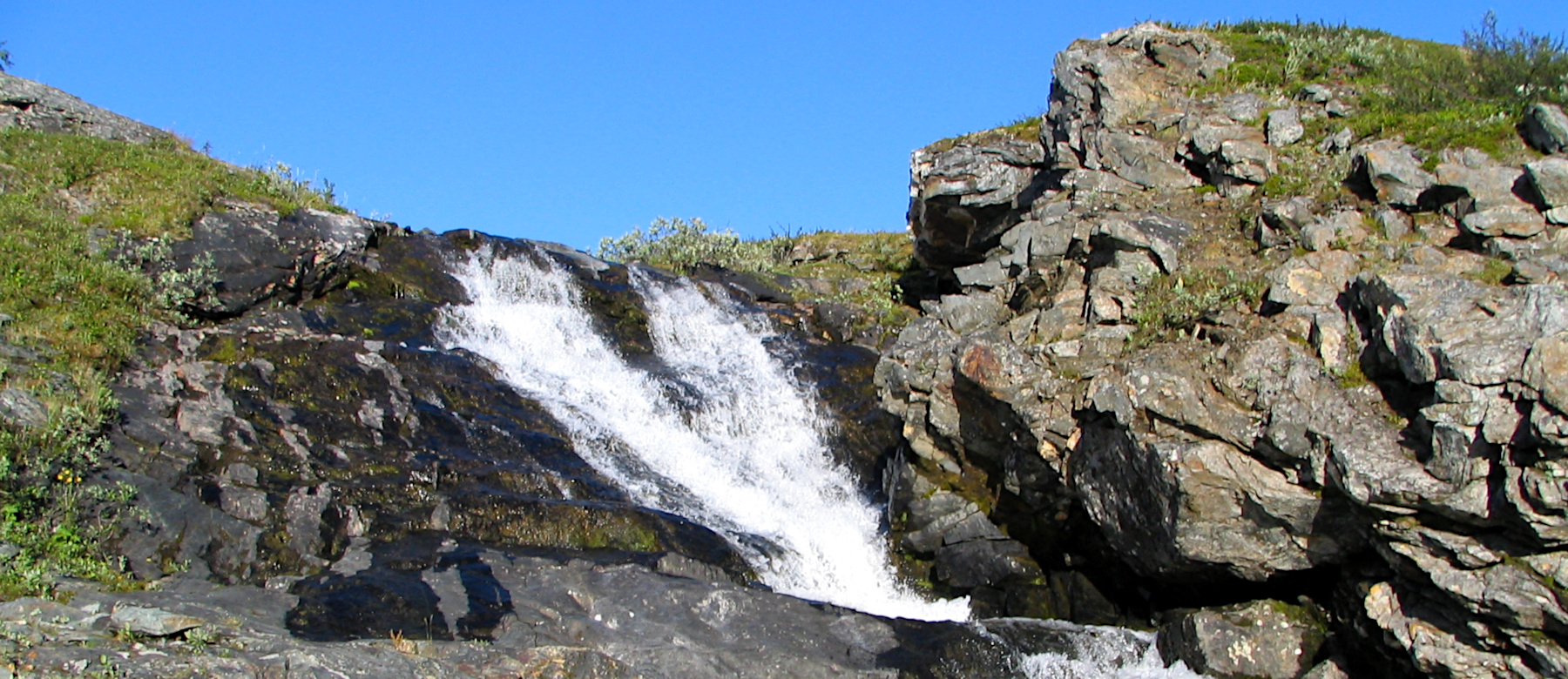
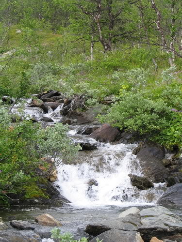
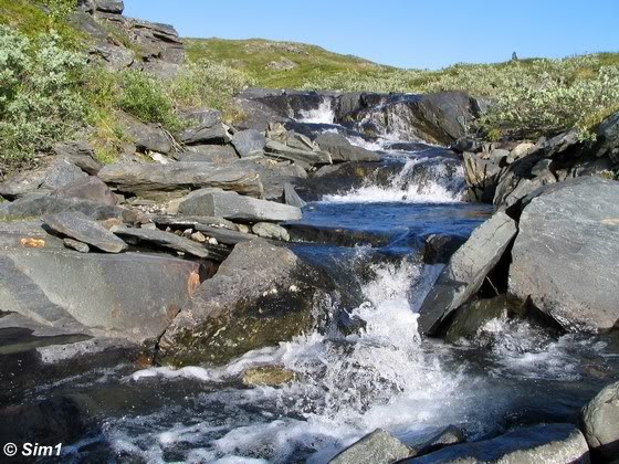
No seriously, it really is great to stretch the legs a bit after dinner and explore the surroundings. As you won't have any backpack to carry with you, this will feel like a lovely leisurely walk. And when you stay at this particular spot, you really have to walk a tiny bit into the valley below. The river cascades slowly down the slopes into the valley below, displaying some wonderful cascades/ mini-waterfalls. We didn't have the energy to walk all the way down into the valley, as this would mean climbing up the same way as well. Hahaha, and that was a bit too much to ask! But we did go long enough to take in some of the wonderful views.
Even if you are not staying for the night at this particular spot, it might be a nice suggestion to make this little detour during your hike. You can leave your backpacks at the top of the hill and walk down into the valley. It isn't too far and it would make a lovely spot to take a break during your hike, for a quick lunch or coffee break. Don't forget to bring your camera though!
The best place to camp when hiking from Såmmarlappa towards Tarraluoppalstugorna was for me here, in the middle of nowhere. Here at this little stream you'll have it all! A nice protected spot for your tent, with a nice level underground. Fresh delicious water at hand (and the water in the Fjällen is the best!) and views to die for!
The location is at the river that has no name (at least no name on the map), which is about 2 kilometres hiking from Tarraluoppalstugorna and about 1 kilometre after getting out of the woods, when walking from the direction of Såmmarlappa. The spot where we put up our tent is on the left side of the river, a little bit down the slope, a couple of metres removed from the river. It is far enough from the hiking trail not to be disturbed by any hikers passing by on the trail above. Although I have to say that we didn't see anyone passing by until later the next morning.
This camping spot is a perfect example how you can use, enjoy and respect the unique right we have in Sweden called "the right of public access" or "allemansrätten" (Swedish).
The rules for camping in the wild are simple: It is allowed to camp in the countryside for one or two nights in the same place. But there are some restrictions. It is only allowed if you are not disturbing the landowner, or the local people. You are not allowed to put up your tent near homes, farm building, a Sami village, or on farmland.
The main rule for the 'right of public access' in general is that you don't damage the landscape or animal life, and you must show consideration for both landowners and for everyone else that is out and about in the countryside. In short: Do not disturb, do not destroy. This is a privilege we have, don't destroy it, don't abuse it. Respect nature; "take only pictures, leave only footprints"
Simone & Åke, Tarraluopal, Sweden, July 2006

It would be great to hear from you!
You can reach me by sending me an Email.
Or leave a comment / reaction in the box below.
You can also follow me on Facebook: Sim1 around the World Blog
:-) Simone