| My pages about the northern part of Sweden |
| My travel stories | My photo impressions | ||
| Rádunjárga | Katterjåkk to Stuor-Kärpel | Abisko | |
| Alesjaure | Sarek | ||
| Unna Allakas | |||
| Kvikkjokk to Njunjes | |||
| Njunjes to Tarrekaise | |||
| Tarrekaise to Sommarlappa | |||
| Sommarlappa to Tarraluoppal |

I love the very north of Sweden. This is the mountain area called "Fjällen" and home to some of Swedens most amazing National Parks (Abisko, Padjelanta, Sarek and Stora Sjöfallet). Endless areas of wilderness, perfect for making multi-day hikes.
We love to go to this area and hike, all from a week up to two week-long hiking trips. On average you can find us in the very north of Sweden each other year putting on our hiking shoes and strapping on our backpacks ready to absorb the vast landscape. This is our 8th trip to the Fjällen and this time we are aiming for the very very north, right at the border with Norway, in a place called "Katterjåkk". And our hiking route will bring us back to Abisko. This is an absolute off the beaten path stretch of hiking. During this first chapter, hiking 2 days from Katterjåkk to Stuor-Kärpel, we only met 4 people in total.
All the photos in the collage below are clickable, so you can view the larger photo.
Hoiganvaggi Hiking Tour, Part 1
Hiking from Katterjåkk to Stuor-Kärpel


We get off the train at Katterjåkk station. It's quiet here, very quiet, and we seem to be the only hikers getting off at this station. And don't imagine that we are getting off the train in the center of some small village or town. Katterjåkk is nothing like that att all. The train stops here at an empty platform, in the middle of nowhere, nothing more than the starting point of the hiking trail towards Unna Allakas. There are no shops, there are no people, only a few building scattered around, but not many. And today it is cold, brrr. Only about 8 degrees Celcius with low hanging clouds and a touch of rain in the air.

We often take the night train up north for our hiking vacations. It is a practical way of transport when having backpacks and hiking poles with us. And we even have a chance to get some sleep during the train journey. And a long journey it is, about 1400 km's, and by train 24 hours in total from our home to Katterjåkk. And well, not so surprising, the train is as usual delayed. Luckily we anticipated that, and left some room between connecting trains so we wouldn't miss the night train. Another train delay follows and in the end we arrive in Katterjåkk around 6 o'clock in the evening.

On the map to the right you can see the first leg of our hiking trip: from Katterjåkk to Stuor-Kärpel. The total distance is 13 kilometers, but as we arrived late during the day, we split the stretch up in 2 days. Our first night we aim to place our tent at the Lake Gátterjávri (Katterjaure), and tomorrow just south of the shelter at Stuor-Kärpel, at the entrance into the valley "Hoiganvaggi".
From the train station we turn left, walk through the tunnel under the train tracks, and from here it is upwards and upwards. The first part of the trail is however easy to hike as it follows a 'relatively' wide dirt road. It is at places rather steep up however, phew, puffing and gasping for air as my feet are trying to find the hiking rhythm!
At the start of the trail we are passing several ski lifts, as this is a popular ski area during winter. They even ski here on Midsummer day! Which is actually less than 1 month ago ;-)


Looking back towards Katterjåkk

Bridge to the winter trail

Gátterjohka flowing enthousiastically
We are slowly walking upwards, I guess 200 meters gaining in height. And on the left side we see the river Gátterjohka flowing enthousiastically. There is clearly a lot of water in the rivers this year!! This is not such good news as it most likely will complicate the hiking and especially the wading of the rivers and streams.
We arrive at a bridge which we almost cross. Oops! Luckily we realize just in time that crossing the bridge here would mean we would be hiking the winter trail instead of the summer trail. And the winter trail is at places dangerous and complicated to hike, so a route one really needs to avoid.

Easy hiking

Approaching the 'Katterjaurestugan' and Suspension Bridge

The 22 meter long suspension bridge over the Gátterjohka

A more primitive 'bridge' over a creek


We arrive at the 'Suspension Bridge' and the worst of the climbing part of today is done. The bridge is 22 meters long, and it dances from left to right with my movement when I cross it. Nothing unusual about that, these suspension bridges always do that. But what is that on the bridge?? Birds nests?? And not just one, about 5 of them!! All in different states of completeness. Are these the nests of a 'Fieldfare', I wonder? The type of nests and the look of the eggs indicate that. Such a crazy place to build a nest, but well, on the other hand, totally safe from preditors. And with not many people doing this hike, maybe not so crazy at all :-)


Towards Unna Allakas
We pass the 'Katterjaurestugan', a cottage which is owned by the Svenska Fjällklubben, and not open for use (unless you are a member). In fact, there are no places to stay on this hike until you get to Unna Allakas (33 kilometers from Katterjåkk) or at the Mountain Hut of Abiskojaure (about a similar distance). So bringing your own tent is needed, no matter which route you choose to hike.
Although located so far from everywhere, this place has quite a bit of history: During the Second World War a group of men was stationed at this house to guard the German posts on the Nordal Mountain. They watched across the lake along the accessable path towards Norway. The group received both Norwegian refugees as well as German deserters during this time. They even caught a German plane that landed on the Swedish side of the lake.
After reading the signs telling about the history of this place, we continue hiking in the direction of Unna Allakas. This is one of the mountain huts that we absolutely loved to stay at during our first hiking trip in the Fjällen. This time however we have to skip a visit to Unna Allakas. The water levels are very high, and we know there is a very difficult river crossing towards Unna Allakas over the river "Vaffojåkka" in front of us. And with this realization, we fear that this crossing might be near to impossible. So we decide to skip visiting Unna Allakas this year and instead directly go to the valley "Hoiganvaggi" (more about this part of our hike in Part 2).

The path continues over meadows along the lake Gátterjávri (Katterjaure)


Relaxing with a nice cuppa tea :-)

Meatballs!
8 o'clock in the evening, and time to set up our tent! We stop at the Lake Gátterjávri (Katterjaure), where there are quite a few great camping spots. Especially on the southern side of the lake where the meadows give a soft and flat base for the tent. And there are quite a few small creeks running down from the mountain, giving ample water supply. And with great view over the lake and the surrounding mountains it is the perfect place to stay for the night for us.
We follow our normal routines and the tent is set up in no time. Åke takes care of the putting up the tent, while I take care of the sleeping arrangements: blowing up the comfy matrasses and taking out the sleeping bags from the backpacks.
And within no time Åke makes a great dinner. Aaah, one gets hungry from all the fresh air and the hiking! A lot of people eat the freeze-dried type of packages on these long hikes, but I don't 'do' those, lol.
No, really, we both like to have some good food during our long hikes and freeze-dried food is not so much our cup of tea. And with some extra planning and preparations at home, Åke always manages to get a delicious plate of food at the end of our hiking day. And today we are having Pasta with Pesto with mini meatballs. Aaah, just what I needed :-)
It's time to close up the tent and get some sleep. Good night everyone!


Cling-clong, cling-clong.... a grunting noise, almost more like honking. I hear it on and off during the night. Sometimes very close, almost beside our tent, sometimes further away.
Clearly not only one, but there are several out there. I know what it is, I heard it many times before in the Fjällen.
Cling-clong, cling-clong, it is the sound of the bells of the reindeers. I always imagine that the loudest honking noice is from the largest male Reindeer, but I really don't know. I lay and wonder a while about the sounds. Relaxing in a way. It is cold outside however, and I am sleepy. So I decide against going out of the tent to take a photo with my camera. I let that though go, and instead let the calming clonging sound put me back to sleep again.... zzzz.
Yawn... aaah, it is morning! Well, that is what my watch tells me anyway. Otherwise it is hard to tell. We are above the Artic Circle, which means we are in the land of the Midnight Sun. The sun doesn't go down here in the midst of summer, as soon as reaches the horizon, it goes up again. Hence, it is light here night and day. Oh yes, that is very confusing! Especially when you are not used to it.
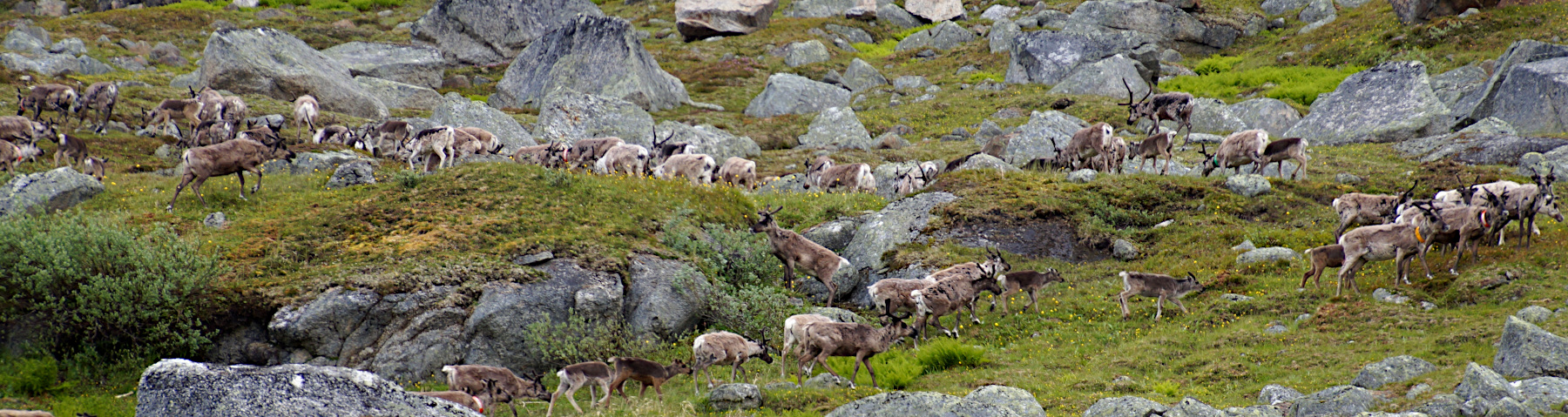
Cling-clong, cling-clong.... I hear the sound again, and that typical grunting, honking sound. I smile on the inside, and probably for real as well. They are still here! The reindeer! And with new energy from a nights sleep I struggle out of my sleeping bag, grab my camera and hop out of the tent. What a sight! Not just one or two reindeer roaming around my tent, but it must have been around a hundred! But as soon as they hear me, they start running up the mountain. They zig-zag up the mountain until they disappear out of my sight.


We eat a good breakfast and break up the tent. The hiking poles are clearly ready to go for another day of hiking. It is the same type of weather as yesterday though, about 8 degrees Celcius with low hanging clouds, brrr, cold. But hiking makes you warm, so here we go. There are snowfields and rivers to cross.....
There is quite a story attached to these hiking poles (photo above); we got them during our first hiking trip in the Fjällen, at the Mountain Hut in Unna Allakas. And I am quite attached to them and never hike without them in the Fjällen area.


Not far into our hike, on the southern tip of the lake, we are treated by another reindeer 'show'. I cannot help it, but I think it is so magical to watch! The first appearance is a small group of reindeer at the tip of the lake trying to cross it. They must have picked up our scent on the hiking trail immediately, as they start running towards the lake within a heartbeat after we spotted them. So we stand quietly and enjoy the sight unfolding in front of us. The reindeer need to roam freely and graze undisturbed, and these mountains areas are their home during the summer. This is their land, and you really need to avoid walking directly towards them; observing them cautiously from a distance is just as great. You can use binoculars, or in my case my zoom lens on the camera instead when you want to have a closer look.
Did you know that Reindeer are the only deer where both males and females grow antlers? And that they are actually really good swimmers? Mosquitoes in the summer drive the reindeer higher up into the hills, but these first few days into our hike, there are hardly any mosquitoes around (heaven!!). Maybe that is why there are so many reindeers present at this relatively low altitude (800 meters).
The quietness and lack of any human presence in this valley must attrackt a lot of reindeer, because only a few minutes later we spot another group. This time they are 'snow surfing' down from the mountain on a large steep snow field. And they seem to do it with so much confidence! It looks like they sit on their bum and that they glide down with quite a bit of speed. We laugh heartedly as it is such a comical sight, seeing 5 reindeer bum-surfing down the mountain :-) Without a doubt they are more secure and confident on the snow fields than I am!
This is the second time I see reindeers glide down on the snow fields like that, the first time was around the Kebnekaise area at Tarfala. And both times it happens so quickly that I didn't manage in time to grab my camera. But the sight is and always will be engraved in my mind.

Boulder-hopping over a small creek

The hiking trail leads us up a hefty hillside

Steep snow field that needs to be crossed

Just south of the Lake the trail splits into the winter trail and the summer trail. This split is not fantastically well signed (except for this initial sign post in the photo above). So keep a close eye on that you will stick to the summer trail.
Also confusing might be the name on the signs. In this case it notes "Storkärpel". On your map you probably see the names in the Sami-language, which is Stuor Gearbil (The Sami are the indigenous people of northern Sweden, Norway, Finland and Russia), or even the name of the mountain shelter called Stuor-Kärpel. And this is one of the many examples, one previously mentioned is the Lake Katterjaure or also called Gátterjávri.
The summer trail turns off to the southwest up a hefty hillside (photo right). The cross-marked winter trail will lead you into a steep race-prone terrain above the river. And it is not fit for hiking.
We slowly struggle up the steep rocky hillside, and when we were almost at the top of this climb.... oh my, a snowfield. But not 'just' a snowfield, but a rather scary one. The snowfield goes steep down the mountain side, and we had to cross it att an angle. Luckily the distance wasn't that long, but with summer arriving these snowfield can get unstable. And well, they are slippery! And at such an angle and steep drop down, not for the faint-hearted! So with my legs shaking, and a panicing look in my eyes, I made it across... phewwwww, a huge sigh of relief. I was expecting some snow-fields during our hike, there often are some. But this time it seemed far more than usual.

Crossing the ridge, and views over another beautiful valley open up in front of us

And from here it is steep down again....

Steep, steep, steep!
Do you see in the photo above, on the bottom right hand side; the little trail leading towards the lake? Well, that is where we are going. And as you guess, somewhere it is going to be steep down to get there.
We are so taken by the views that we walk on, more staring at the view, than at the trail. And somewhere, yes, somewhere, we loose the trail....
We are obviously not the only ones taken this route, so more people are most likely too mesmerized by the view to pay attention to where they are going. And all of a sudden we are stuck on a very STEEP way down, with huge boulders in our way. Going back doesn't seem an alternative (but in hindsight probably would have been best), so down we go. And honestly, I am totally freaking out by this time, and get stuck halfway the trail. Not even the 'bum-way' going down is working. But Åke is a star! He helps me, and my backpack, going down on these huge boulders (that are almost higher than me). Going down with a 20 kilos backpack is an absolute horror. But, we made it! Phewwww, an enormous sigh of relief.


We hike in a good mood onwards. The landscape has changed dramatically but it is also a 'relatively' flat area, so this part of the trail is much easier to hike. The wind is picking up and the temperatures are feeling lower due to it. The landscape is turning cooler as well, with mainly rocks and big boulders. And the grey-tones, and the sharp harsh forms of the rocks hardly give me a cozy and fluffy feeling. Brrrr, I secure my cap and put on my gloves; it is good that we are well prepared for the hike and have enough layers of clothing with us to keep us comfortable and warm.
We pass a little rapid in the river and decide this is a good spot for a short break. Time for a late lunch! And as usual we warm some soup, a "Västkustsoppa" (West Coast Soup) is the choice. The funny thing is we never eat this at home, but it is our favourite soup during our hikes in the Fjällen :-)

I am navigating my way through the harsh landscape. It is like the giants have played a game here, scattering these big boulders all over the landscape. The small trail is serpentining through the landscape, zig-zagging around the boulders, leading us slowly but steadily further south.


This is actually a very international hike ;-) Approx. 1 kilometer of the hike leads us through Norway. Åke is posing at the border crossing from Norway to Sweden. The sign is hard to read, but is says in Norwegian "Riksgrensen mot Sverige".

todays final hurdle, crossing the broken bridge
One final little hurdle, a broken bridge. We need to cross it before we reach the end of todays hike: the entrance to the valley called "Hoiganvaggi". It takes some creativity to cross this little bridge, but it is not a big hurdle, so we are over it in no time.
The real hurdle is only a short distance from here: the river crossing over the Dossagemjávri. The hiking trail leads us directly to the rivers edge, and Åke and I look at each other, we shake our heads..... impossible to cross right now....
No way we will be able to cross this river safely today. The water level is high and the flow is powerful, it will just be too dangerous to attempt. So instead of crossing the river right here right now (the usual route described in our guidebook) we decide to stay on the north side of the river instead. It somehow fits into our hiking plans anyway, as our next stage in the hike is hiking through the valley called 'Hoiganvaggi', which is to the left. Preferable to hike on the south side of the river, but why not start on the north first, and find a more suitable river crossing later? So that is what we do.
We walk maybe a kilometer into the Hoiganvaggi valley, and we find some great spots to put up the tent. Tomorrow we have new challenges to overcome: crossing this river somehow, and start the hike through the Hoiganvaggi, a route that is not marked and has no trails....
But more about all that in my page "Hoiganvaggi Hiking Tour, Part 2", which I hopefully finish writing soon :-)
What remains for today is setting up the tent, having dinner, and relax the rest of the evening. Good night all, hope to see you soon on the next leg of my trip :-)
Simone & Åke, Katterjåkk, Sweden, July 2019
It would be great to hear from you!
You can reach me by sending me an Email.
Or leave a comment / reaction in the box below.
You can also follow me on Facebook: Sim1 around the World Blog
:-) Simone