|
||||||||||||||
Roundtrip Norway, July 2003
Selje, Vestkapp and Kråkenes

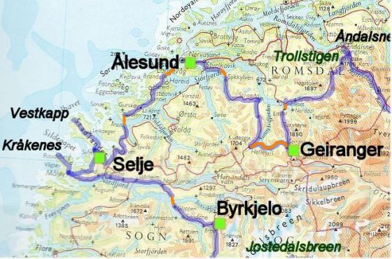
Map of this part of my roundtrip
I doubt if a lot of you have heard of Selje before, as it is such an off the beaten path, so I'll start by giving you some idea where Selje exactly is. Selje is located on the west-coast of Norway, 565 km north-west of Oslo, 341 north of Bergen and 381kilometres south-west of Trondheim. Locations that are closer by and where you might think of going yourself on a trip to Norway is Maløy located 46 km to the south; Geiranger is 186 km to the east and Ålesund is 115 km to the north.
Selje is only a tiny little village but a great starting point to explore the area. We did some daytrips to Vestkapp and Kråkenes and enjoyed some fantastic views. As our campground was located next to a golf course we didn't waste the opportunity to play some rounds of golf as well.
The map might make it a bit more clearly for you where Selje is exactly located. The blue line on the map is the route we took, the orange lines on the map indicate the ferry routes and the green dots are the places we stayed overnight.
The road to Selje
The road to Selje
I arrived in Selje after a long drive from Ålesund. We decided to do some island hopping to get to Selje, a route that required taking the ferry twice. The total length of the trip was about 115 kilometres long. The first ferry we had to take was from Sulesund to Hared. This ferry takes a bit longer than usual: 25 minutes. Catching the ferry won't be much of a trouble as it goes 35 times a day. A car including driver costs 71 NOK; a passenger 25 NOK.
The second ferry, from Årvik to Koparneset, was a bit shorter and takes 15 minutes. It also goes quite often: 32 times a day. A car including driver costs 43 NOK, a passenger 18 NOK. You can find more info about the ferries in Norway on this website: www.mrf.no
I enjoyed this trip, but the only bad thing is that the weather wasn't so good, so I don't have many pictures of the drive to here. Selje is a real off the beaten path location, but a beautiful area and absolutely worth a visit! If you don't want to do this island hopping (as it is quite time consuming) and want to skip Ålesund (which what I would do a next time) a much easier way to get to Selje is arriving from the west. Just follow the Nordfjord but instead of going to Maløy, head north on the last little bit of the journey and you'll arrive in Selje.
Getting closer to Selje
The closer you get to Selje the more you feel that you are going off the beaten path. It is so quiet here but really picturesque.
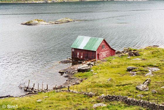
The route to Selje follows some fjords, has some really winding roads up and down the mountains and the further you get, the more you doubt there will be civilization at the end of the road. But there is! The area is very sparsely populated, but you will see some houses, sheds and fishing boats on your way over here.
Towards Selje
The village of Selje
The village of Selje
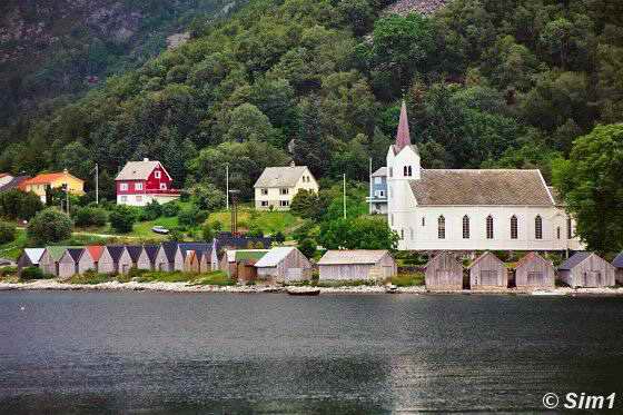
Selje is a small village with only 1500 inhabitants, but it is a pleasant little village. Just outside the village is a campground. It is very small and very basic, but it is clean and that is the most important part. There are some stores in Selje that provide you with all you will need during your trip, which is a real plus. Selje also has some beaches, but the only bad thing about it was that I didn't have any great weather to be on the beach ;-) Eeks, too much rain and clouded weather! Although I have to say that the sun did surprise me on one afternoon and made perfect weather for a round of golf. Selje itself isn't the reason why you want to go to this area, as it hasn't that much to offer. It is the beautiful surrounding area and the tranquillity that will attract you to this place.
A main attraction at Selje is the monastery and the church of St Sunniva on Selja Island from the 11th and 12th century. I didn't go here as I didn't have enough time, so I can't tell you that much about it. One point of warning though: you need a ferry to get to Selja Island, and they only go from 25th of June to the 5th of August. You can get more info about the ferry at the tourist office (tel : 57 85 66 06)
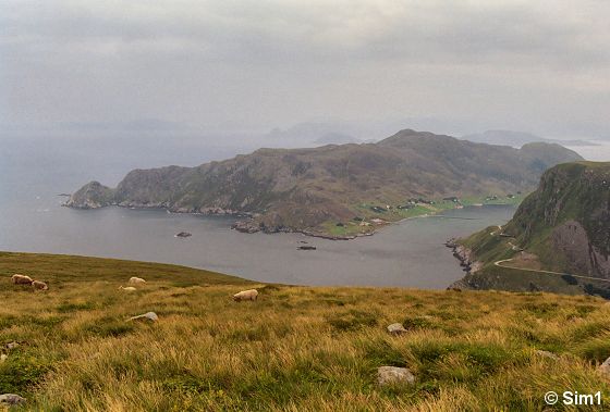
View over Selje
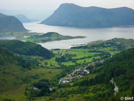
View over Selje
It is time to get into the car and explore the area. To get out of Selje you have to follow a winding road to the top of the mountains, it doesn't matter which direction you decide to go to, you have to pass those mountains first. Hahaha, it can make you a bit car sick though, racing up and down the road with all those hairpins. But when you arrive to the top you will have some great views over the village of Selje and its surrounding area. In the middle of the picture you can see with the golf course and camping site.
View from west Stadlandet over the fjords
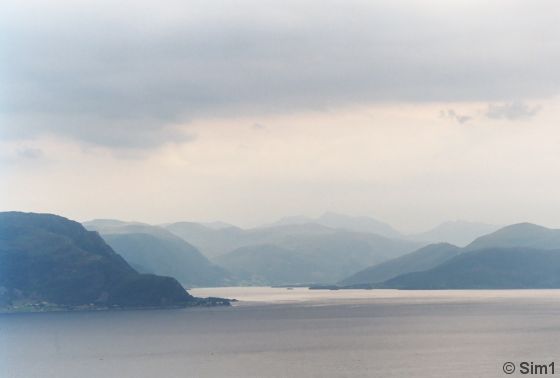
View from west Stadlandet
We are driving north on the peninsula of Standlandet and the views you have along this stretch of road are fantastic. It is so hard to describe this beautiful landscape in words, but when you look at the photo you'll probably know what I am trying to say. Even on a cloudy (and sometimes rainy) day like this the views amazed me, so tranquil, so beautiful, it took my breath away. I can only dream of how it would look like on a sunny day.
Vestkapp
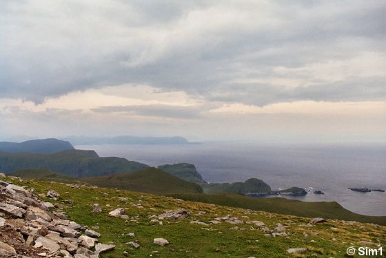
Vestkapp
After a beautiful drive of 32 kilometres from Selje we arrived at Vestkapp. Vestkapp is on the northernmost tip of the Stadlandet peninsula and my travel guide book wasn't joking when it predicted that there would be some fierce winds at this lookout point. When I got out of the car, the car door was almost blown out of my hand because of it. Oops.... it was much windier than I expected! But I caught the car door just in time :-)
There was also a drizzle of rain, and together with the strong winds it felt bitterly cold. So I didn't have to think long to make a run for the little restaurant that is located here, to find some shelter. The restaurant isn't great, but you can get some coffee and simple dishes here. Mmmmm, and a hot cup of tea or coffee tastes delicious on a rainy windy day and like this :-)
Enjoying the views at Vestkapp
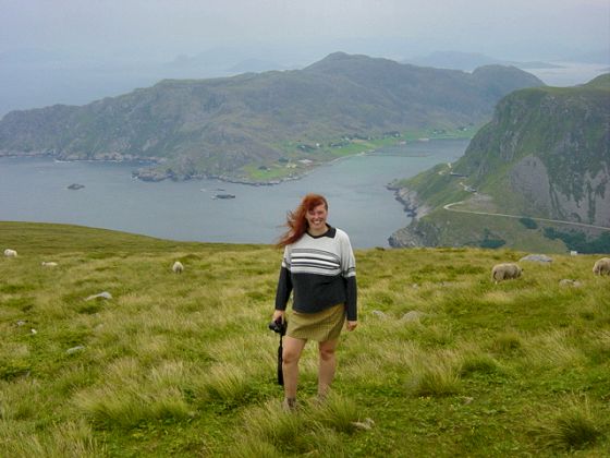
Enjoying the views at Vestkapp
After the nice cup of tea it was time to challenge the weather outside. Hahaha, yeah, yeah, I know! You don't need to say it, it is rather strange to wear a miniskirt on a day like this! But when I left Selje it was nice weather and as I was feeling optimistic, so I had hoped it would stay like that ;-) I guess I was out of luck today. But nothing was going to stop me from enjoying the beautiful views here at Vestkapp; not even the weather! I tossed on a sweater grabbed my camera and started hiking down the hill.
I have to admit that the rain was being nice to me and decided to stop falling down for a while. The views were so beautiful that I forgot all about the weather and wandered further down the hill than I intended. Eeks, walking down is fun and easy to do, but climbing back up the steep hill was another story, lol. Hahaha, Åke was more sensible than me and didn't walk that much down the hill. He was patiently waiting for me at the top, smiling at me, while I struggled my way back up the hill. I was puffing out of exhausting, but smiling and feeling so happy. Norway is soooo beautiful!!!
Selje, Vestkapp and Kråkenes
The view from Vestkapp
Let me step out of the way so you can see more of the view yourself. Unfortunately the pictures turned out rather dark because of the cloudy weather :-( But maybe it will give you a slight idea why I am so enthusiastic about the place.
The name Vestkapp is rather confusing for this area as it isn't the most westernmost point of Norway as the name suggests. It is the westernmost of the mainland of Norway, but I think that doesn't really count ;-) The views over the sea and the coastline are fantastic, and make it worth to drive all the way up it. The lookout point at Vestkapp is 486 metres high and the cliff is called Kjerringa.
Winding roads at Vestkapp
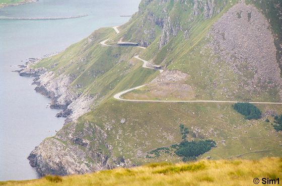
Winding roads at Vestkapp
I am zooming in a bit with my camera on the surrounding landscape. You can see the roads winding around the cliffs bordering the sea. The landscape is rough, but oh so beautiful.
The cliffs
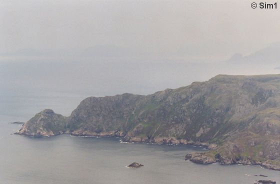
The cliffs
Zooming in on the cliffs across the fjord; here the fjord ends up in the sea. It was such a pity that the weather wasn't so good. I wonder how far you can look on a clear day.
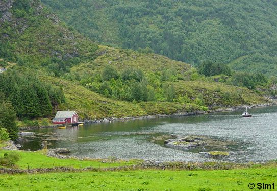
Ervik Chapel and graveyard
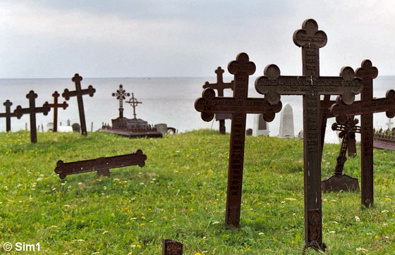
Ervik Chapel and graveyard
Just south of Vestkapp, on a little side road from the main route, you can get to Ervik; a tiny little village on the west coast. At the end of the road is the graveyard and chapel of Ervik. There is something mystic about this place. The cemetery is overlooking the sea and is much older than the chapel of Ervik, which dates back to 1970. I spend some time here as the graveyard is so peaceful with all the old graves. In the background you can see the sea and the roughed cliffs, giving it something special.
Traditionally the graveside ceremonies were conducted in the open air at Ervik. But when the express coastal steamer St.Svithun shipwrecked at Buholmen off Ervik in September 1943 they decided it was time for a memorial chapel. Unfortunately I run out of film on this moment, so I don't have any pictures of the chapel itself.
Back home in Selje with some yummy food!
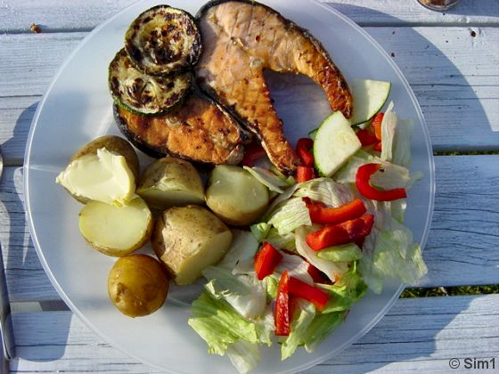
Back home in Selje with some yummy food!
From Ervik we drove back to Selje, were we had a relaxing evening and a great dinner. Who says camping food can't be good??! It tasted delicious. Fish on the menu today, salmon grilled on the barbeque. When you are in Norway you can't escape trying out some good fish. And I love fish, so I felt right at home. The salmon was served together with some fresh potatoes and salad, yummie! Compliments to the cook! Hahaha, I think I am getting hungry again ;-))
Yummy dessert!
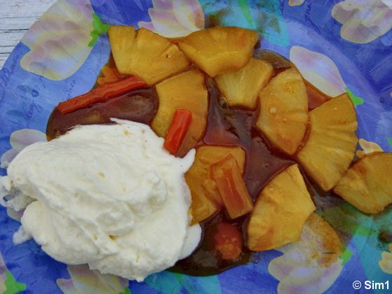
Warm pineapple from the wok, with whipped cream on the side
But Åke had more good food in store for me; a yummie tasting dessert! :-)) This is warm pineapple from the wok, with whipped cream on the side. Mmmmmm, makes my mouth water!
Playing golf at Selje
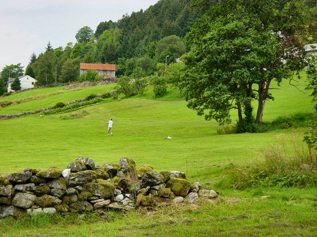
Playing golf at Selje
How could I have done this??? Picking a campground next to a golf course???!!! Eeks!!! Hahaha, I guess it was fate, lol Åke loves golf, so there was no escaping going for a couple of rounds of golf. I didn't golf at the time myself, but I had a good time joining him on his rounds. The golf course is a 9 hole course, hilly, different maybe you can even call it strange, but fun! And hilly is no joke, it really was going up up up and down down down, lol. But what else can you expect in mountainous Norway ;-)
A big advantage of golfing in Norway during the summer is that the days are long. It stays light forever, so you are able to golf until late in the evening. This way you can perfectly combine sightseeing with some golfing fun in the late afternoon and evening.
Time to leave....
Time to leave....
It is time to say goodbye to Selje and the peninsula of Stadlandet. Today we are going to Kråkenes, where there is a lighthouse and a beautiful stretch of coast. I almost changed my mind in going there, the sky was cloudy and threatening with rain. But I still had hopes it might clear up a bit during the day..... invane :-(
Selje, Vestkapp and Kråkenes
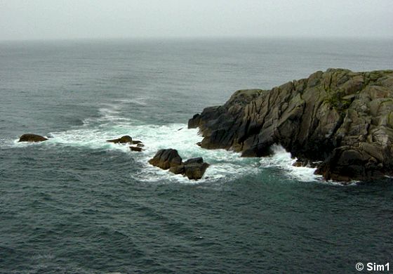
The coast at Kråkenes
The wind was blowing, it was raining slightly and the waves crushed into the cliffs at the Kråkenes fyr. I love the see on a windy day, when the wind blows in my face. Only wish those raindrops wouldn't come done :-(
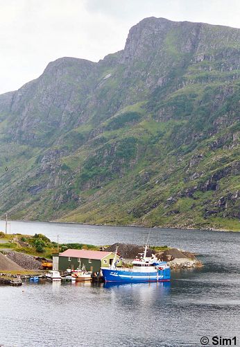
Kråkenes is located on the northern point of island of Vågsø, at the end of the Nordfjord. The main city on this island is Maløy.
Walking up to the lighthouse
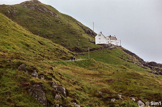
Kråkenes Lighthouse
Halfway up the hill you can see the Kråkenes Fyr (Fyr means lighthouse is Norwegian). You can't reach Kråkenes fyr all the way by car, you have to park it at the bottom of the hill and walk your way up to the lighthouse. I was happy to have an umbrella with me as it protected me a bit from the wind and the rain. It was a hazardous occupation though, hahaha, the wind was fierce and trying to keep the umbrella in one piece wasn't an easy task.
Kråkenes Fyr
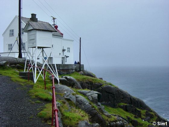
Kråkenes Fyr
Aaah, finally at the lighthouse! To me it didn't look really like a real lighthouse, but it certainly is. The light is on the other side of the building at the edge of the cliffs. A logical place of course as this is where the ships can see it. As the lighthouse is already high up on the cliff it doesn't need a high tower to have the light on, so this makes it look more like a normal house than a lighthouse.
Kråkenes Fyrkafe
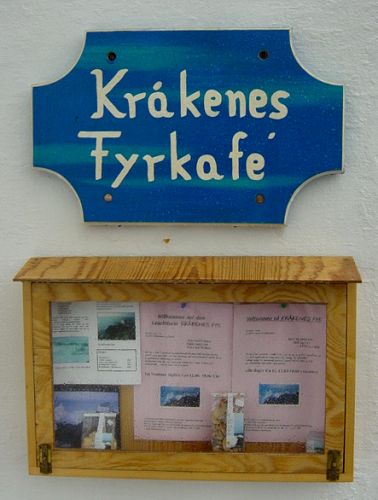
Kråkenes Fyrkafe
The fun thing is that you can go inside the lighthouse to have a coffee or a light snack. And besides that it is also a hotel! So if you like you can stay here overnight :-) I have no clue how expensive it is though, but here is a phone number where you can get more information + 47 57 85 55 27
Tea and waffles at Kråkenes Lighthouse
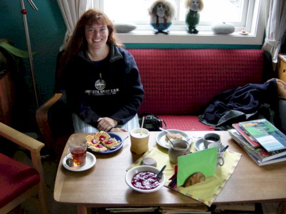
Tea and waffles at Kråkenes Lighthouse
It was really cosy inside the lighthouse, a perfect location to have a cup of tea and waffles. At the lighthouse they also have a small selection of books that you can buy. They are all about lighthouses and this region of Norway, they looked great, although a bit pricy in my opinion. There are several copies of them lying around which you can browse through and make up your might if you want to buy them or not. It made it all so nice and cosy here.
Hahaha, I have to admit it was hard to leave the lighthouse again! It meant being confronted with the cold windy and rainy weather, brrrr. But at least the way back meant walking downhill, hahaha, and that goes a bit faster ;-)