| My pages about Montenegro |
| My travel stories | My photo impressions | ||
| Kotor and its charming old town | |||
| The lovely village of Perast | |||

June 2019, we decided to make a spontenous trip to... well, to somewhere?! We had no idea really where to go, so we started brainstorming about possible destinations, and Åke mentioned "maybe, Montenegro"? YES!! I quickly cried out, what a fantastic idea!! That would be perfect!
A few years ago, when we visited Croatia, some of the locals mentioned that we probably would like Montenegro because of its beautiful nature and possibilities to hike. And so we decided right away, without really knowing anything about this little country at the Adriatic Sea, to book our flight. So quick preparations started, and as I had heard of Kotor over the years, I looked up some info about this place. And seeing some photos of the beautiful Fjord-like landscape, it was an easy decision, Kotor would be the first stop on our trip to Montenegro. And a week later, we were here, in Kotor!
All the photos in the collage below are clickable, so you can view the larger photo.
Kotor and its charming old town
Montenegro

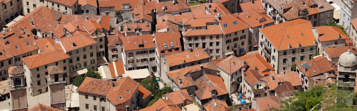
View over the Bay of Kotor, photo taken high above the town of Kotor, towards Lovcen National Park.


View over the old town of Kotor
I knew I wanted to travel to the Bay of Kotor, to visit the historic town of Kotor and the beautiful Fjord-like landscape. And we also wanted to do some hiking during our trip.
My husband Åke, searching online for hikes in the Kotor area, found tips about a great walk to the Kotor Fortress. A walk, not all too long, up the mountain at Kotor from where we would have some marvellous view over the blue waters of the Bay of Kotor and the charming old town of Kotor.
Kotor is also part of the UNESCO site "Region of Kotor"

The hiking trail
The Hike to the Fortress of Kotor


Oleander in bloom at the start of the hiking trail
We have an app on our phone that records our walks, which is quite fun (the App is called Komoot). The map on the left side is our recorded walk, if you click on it you will have a better view of the actual walk. But clearly visible, even in the small version, is the serpentine trail up to the Fortress of Kotor.
In total our walk went up 260 meters to an altitude of 320 metres. In the little graph below the map you can see the height differences during the walk. Green is ok, but the more red in colour the line gets, the steeper and more strenuous the trail gets.... oops!
The hike we did was approx. 4 kilometres, which didn't include the stroll through the small streets of the Old Town of Kotor. It took us almost 3 hours to complete, but we took a lot of stops on the way. I would say it would take you 2 to 3 hours when you take it leasurely.
The most common route for this hike is to start from the Old Town. We opted for another route however, starting just outside The Old Town. The start is at a dead-end street called "Tabacina", right outside of "Apartments Ana" (Google coordinates for the trailhead: 42.427204, 18.773355). It is the old Pedestrian Trail that connected Cetinje with Kotor and was used by local women taking their goods to the market in the Kotor Old Town. This trail is also the starting point for the hike "The Ladder of Kotor", or also known as "The Ladder of Cattaro".
The starting point to this hike wasn't the most charming (photo to the left), although, the Oleander along side the path was blooming vigorously! We passed the blue fence that was in front of us on the right side, and there we found the small trail. Don't let the start confuse or discourage you, this is the right trail! And within a few minutes you will start having some beautiful views.

The trail was well marked with brightly painted red and white dots

I really enjoyed taking this route, going up on the backside of the mountain, having views over the Fortifications and also over the blue waters of the Bay of Kotor. Making this a circular route made us also able to see both sides of the mountain. This first part of the trail is really charming: the serpenting trail, with the enormous amounts of wildflowers, was something I wouldn't have liked to have missed!
The trail is really well marked with brightly painted red and white dots along the path.

The hiking trail

Åke patiently waiting for me :-)
Within no time we gather height. The trail zigzags and zigzags some more, climbing quickly upwards. In this first part of the trail, it must have been 30+ switchbacks on the trail. The fortifications that first towered so far and impressive above us, start to get closer and closer with every switchback we take, and after a while we even started to look down upon parts of the fortifications.
Construction of the fortifications to protect the town from invaders have been ongoing since the 9th century, all the way through to the 19th century. But it was the Venetians who constructed most of the present structures. Besides the Venetians also the Illyrians, Byzantines and Austrians left their mark. Unfortunately powerfull earthquakes have occured in this area, the latest one being in 1979, and they unfortunately damaged the fortifications.
The fortifications, making a full loop up into the hillside, are 4,5 km in length. The walls are lite up at night, and we were even able to see this 'arch' of light from our balcony in Perast.

The Fortifications of Kotor


Cool drinks nearby :-)
Did I tell already how warm it is today? it is a hot hot hot 35 Celcius today! Phew, and in the full sun, doing a steep climb, this little sign is seen as a blessing to us :-)
Maybe not exactly because of what it says on the sign: "Smoked ham, Cheese, Scotch - Rakia", but because it means that some cool drinks are nearby!

A nice relaxing break, enjoying the fabulous views over the Bay of Kotor

Lazy cat purring in the shade beside us


The cat is purring beside me on the terrace, using a stone as a pillow, and enjoying an early afternoon sleep in the shade. Like us, it is probably escaping from some of the heat of the day. In my hand I have a nice ice-cold drink, and in front of me the most amazing views over the fortifications and the the clear blue waters of the Bay of Kotor. Honestly, I could have stayed here for hours and hours without a problem. It was such an enjoyable break in our hike!
The owner is so very friendly, but has only a limited knowledge of English. And as my Montenegrin is unfortunately non-existing, asking for directions was not the easiest. But, with some hands and feet, we are able to communicate :-) We are what is called on google maps at the "Cheese Shop", and exactly here there is a side-trail to the right leading you to the Fortress. It is located approximately 2 kilometres from the start of the hike, 1 hour of walking and at almost the highest point during our hike.

The views from the terrace are fantastic


Ruins of the village of Špiljari
We are back on the trail again, and the trail has changed in character compared to our first part of the hike.
Instead of the blazing sunshine, we now walk through a nice tree-shaded area. But all of a sudden in front of us are the ruins of the village of Špiljari.
As we had such a short time to prepare our trip, we had no idea where the trail exactly would lead us, so the sight of these ruins took me by surprise, and instantly made me wonder about its history.

church Saint John, Špiljari


The inscription above the door, church Saint John, Špiljari

Church Saint John Špiljari
The little church Saint John in Špiljari is not much more than a ruin itself. The roof is covered with plants, and it seems only a matter of time before it all will colapse and turn to ruins as well.
But, this thousand year old church wasn't without it inhabitants! Nothing of a church interior is remaining, instead it is the home of a tired looking donkey. And also a cat seems to have made it is home, looking content and lying lazy in the window of the church. The only life outside are some goats roaming around. Otherwise the whole place felt eerie and deserted.


Sign on the other side of the wall pointing to the 'window' to go to Špiljari
We continue on the trail, and only a short walk from the village we get to the fortifications. But now where to go???
It looked like a dead end here. It took me a second to realize we had to climb through a large window in the wall of the fortifications to continue the trail. Not the most pleasant experience when you have some fear of heights like me! But I never give in, so I bravely made the climb through the window ;-) And being totally honest, it wasn't all that bad, or dangerous. You just need to pay some good attention when you climb into the window, which requires quite a big step up to do so.
Climbing through the window is like climbing into another world. From the eerie deserted village of Špiljari, we now see quite a few people walking up and down the stairs towards the Castle.

The flag of Montenegro

My travel-bear and mascotte "Nalle" overlooking the Bay of Kotor
We turn left and we climb further upwards towards the Castle where the Montenegrin flag is happily waving in the wind against the clear blue sky.
The
castle itself was quite a disappointment to me however, a mere ruin, and not a very charming one.
But the VIEW... WOW! Fantastic! And this hike is without a doubt all about these fantastic views and absolutely worth the hiking effort.
On the photo, above right, you can see my travel-bear and mascotte "Nalle" overlooking the Bay of Kotor. This little mascotte has become quite the world traveller, having his photo taken in each country he visits at some interesting and distinct place. And this view over the Bay seemed a very appropriate one to represent Montenegro.
The Bay of Kotor or in Montenegrin 'Boka Kotorska' is also referred to as simple and short "Boka" or "the Bay". For the ones that have been in Norway, you will strait up feel a similarity with the beautiful Norwegian Fjords. Not surprising with the cliffs plummiting into the narrow inlet of the sparkling Adriatic Sea. Some even call it Europe’s southernmost fjord, but this is technically not correct. It is not in the sence a 'Fjord¨, as it not has been carved out by glaciers. Instead it was created when rising sea levels drowned a river valley. Nevertheless, it is just as beautiful, no matter how it was created :-)

Amazing views from the castle

Walking down the 1350 steps


It is time to walk down towards the Old Town of Kotor. But it is not 'just' walking down, it is going down many steps on a very small path. And it is far steeper then the photo above suggests! In total it is 1350 steps, although I didn't count all of them myself ;-) Walking down is not that easy on the knees, actually the path on the backside of the mountain was much easier to walk on. And on this part of the trail there are far more people as well! But I guess I was quite in luck as there was no cruise ship in the harbour of Kotor, so it was relatively quiet on the trail as well as in the Old Town. Alongside these steps, there is a very slippery rocky pathway, which was needed to let other people pass by. It was so slippery in fact that I almost slipped and fell at one point, even with good walking shoes on! So some good footware on this walk is highly recommended.
Visiting here in middle of June was an absolute joy as so many wildflowers were in full bloom. Not only I, but several other we met on the trail were blown away by the natural beauty this created. Below us we could see the Old Town of Kotor with its characteristic red tiled roofs. The views were wonderful from above, looking out over the small streets of Kotor, with its historical houses and many churches. So we zig-zagged slowly down, stopping regurarly to soak up the ever changing views.


The Old Town of Kotor

We finally climbed down the 1350 steps and are back in the old time. We pass this mysterious arch close to the River Gate and are quickly absorbed by the small cosy streets of this little town. But before just getting 'lost' in this historical town we decide to go in search for some lunch. And we ended up on a terrace in one of the squares of Kotor, at restaurant Astoria. Instead of ordering one big main dish we opted to order some smaller dishes to share. And being here at the coast it is an excellent choice to go for seafood. And the mussels here were absolutely delicious!!
With so little time preparing for this trip, I knew so very little about Kotor. But maybe that was actually a very good thing. This gave us the chance to just get ¨lost' in the small streets and wander around as we wished, absorbing the views and the atmospere as we liked.
The town of Kotor has however a rich and long history. It was founded by the ancient Romans as Acrivium. It was ruled from Byzantium in the 10th century. And it was Venitian and Hungerian during several periods in its history.

Delicious lunch at Restaurant Astoria


The clock tower in the main square of Kotor, Grubonja Palace


Pima Palace on the Flour Square


St. Mary’s Church


Kotor seems to have a love for cats, and you can see them everywhere. The real-life purring versions, lazying around somewhere on the city wall finding some cool in the shade. But also the stone version in many of the shop windows, with even specialized cat-souvenir shops. Maybe not as surprising as the Cats of Kotor are believed to be a symbol of good luck.


Cathedral of Saint Tryphon


St Lucas’ Church


It is time to say goodbye to Kotor, and we slowly strole out of this lovely town back to our car. And once more we pass this mysterious arch that marks the way to the fortifications up the hill.
The inscription in Latin says "Regia Munitae Rupis Via", or freely translated: 'royal road to the cliff fortress'. It clearly shows the winged lion above it, and also the date, 1760, in Roman numbers (although not visible in this photo). This is the Winged Lion of St. Mark's, which I also spotted while walking around in Perast. It is the symbol of Venice and shows the historical links between Kotor and Venice.
Simone & Åke, Kotor, Montenegro, June 2019

It would be great to hear from you!
You can reach me by sending me an Email.
Or leave a comment / reaction in the box below.
You can also follow me on Facebook: Sim1 Travels Blog
:-) Simone