| My pages about Iceland |

September 2020: Who would have thought this would be possible, that we would travel abroad autumn 2020! But we did! We found an opportunity at the very VERY last minute to travel to Iceland! It meant 1 week in quarantine in a nice little house in middle of nowhere, but with great views! And 2 weeks of travelling around the whole island. And being able to travel here during the Covid time has been such a unique opportunity, with hardly anyone around and being able to experience the amazing nature without disturbances.
For now this page will be a sort of photo collage, but hopefully some day soon I will have some time to write a bit more in depth about my visit to Landmannalauger
Landmannalaugar lava fields
Iceland

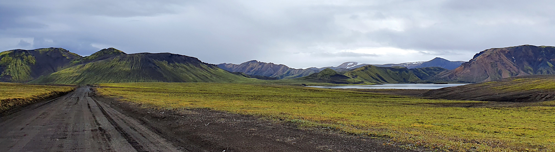
We thoroughly enjoyed our hike through the lavafields at Landmannalaugar today. Even the drizzle of rain through parts of the day couldn't spoil the beauty of this place. But luckily even some rays of sunlight managed to break through the layer of clouds brightening up the colourful mountains this area is so famous for. The landscape is unbelievable rugid and beautiful! It was quite a long drive to get here, but absolutely worth it!

But before I continue with my impressions of Landmannalaugar, please let me give you an idea where you can find it on the map. Landmannalaugar is located in xxxx region of Iceland. It is about xx hours / xx kilometres drive north east of Reykjavik.
location on the map: 63° 99,084'N, 19° 06,278'W
Another important thing is to ensure a filled gas tank because of no gas stations near and in Landmannalaugar.
F- roads
The journey

Mount Hekla


whooper swan

Sigöldufoss

Sigöldufoss is 11 meter high and 40 meter wide waterfall along the river Tungnaá.


Landmannalaugar


Oops...... and than happens what should not happen....
We are really out in the middle of nowhere, stranded on this bumpy road of black lava sand surrounded by nothing else than this harsh vulcanic landscape. The nearest point of civilisation is about 22 kilometers in front of us, and absolutely no one around or expected to drive on this road in the coming hours.
The only living organisms we saw on this gravel road are a few stray sheep. There are no trees, there is no vegetation. Nothing that really grows out here, except for the always present large patches of moss, that are clinging to the bare vulcanic rocks. And on such moment reality strikes, I realize how alone and far away of everything we are.

As we were going up into the highlands, the mountains covered with green moss looked surreal. I have never seen so many shades of green and browns mixed together to create such a scenic landscape which certainly didn’t look like from our planet Earth


https://guidetoiceland.is/travel-iceland/drive/fjallabak
https://www.extremeiceland.is/en/attractions/fjallabak-nature-reserve

Hnausapollur Crater (Bláhylur)

Hnausapollur is a stunning blue lake nestled in a crater that formed about 1100 years ago in a short explosive eruption. It is about 30 hectares in area and is one of those lakes in Iceland that are known by two names: Hnausapollur and Bláhylur. It lies in a crater near Mt. Tjörvafell, just north of Lake Frostastada, at an altitude of 570 metres. It looks a lot like its neighbor, Ljótapollur, but the access and drop from the edge of the crater down to the lake is considerably easier. There are special brown trout in the lake, but they are small and few feel it worth clambering down to fish for them. A ring road skirts the crater edge and from there it is a quick walk to go up to the highest point for a still better view.
Sitting behind a volcanic ledge, right off the road to Landmannalaugar, hides an enormous crater. Hnausapollur erupted around 11,000 years ago, now it's filled with piercing blue turquoise water. Those in a 4WD can drive right up to the edge of the crater and peer into it from the car. It's also possible to carefully walk around the rim or obtain a permit (3500kr) from the Mountain Mall and go fishing in the lake below. There's no road sign on the F208 pointing out this magnificent sight, which is around 200m from the road. Look for a dirt path leading up to a hill on the left before you reach Frostastaðavatn lake. Hnausapollur also has another name, often called Bláhylur because of the turquoise blue color of the water. It is a highland lake in an altitude of about 570 meters above sea-level.

Hnausapollur Crater (Bláhylur)


Laugahringur circle hiking trail


Time for some hike statistics:
We have an app on our phone that records our walks, which is quite fun (the App is called Komoot). The map on the left side is our recorded walk.
If you want to do the exact same hike as we did, you can find the link here: https://www.komoot.com/tour/254738912
Starting point: Landmannalaugar Tourist information Centre
GPS starting point: 63° 99,084'N, 19° 06,278'W (click to open coordinates on google maps)
Type: loop trails
Length: 4,4 km.
Total height difference: 120 m
Highest point: 770 m, Lowest point: 670 m
Trail signs: xxxxx well marked
Difficulties: This is the shortest and easiest of the day hikes. It goes from the Landmannalaugur hut along the beginning of the Laugavegur trail on a smooth path through the lava field. When it gets out on the other side, it loops around, coming back through a different, rougher, part of the lava field. there are some minor exposed areas where it's important to keep your balance.

We layered ourselves with waterproof jackets, caps and gloves.


This is the most accessible and most popular hiking trail in Landmannalaugar. It is a “circle” through and around the Laugahraun lava field. In 1477, an eruption from the slopes of the Brennisteinsalda volcano gave birth to this small lava field. Although small, it is one of the most interesting lava fields you can find in Iceland. The regular basalt lava is blended with numerous shining black obsidian rocks—a combination exclusive to only a handful of other fields in the area. The hike starts at the FÍ (Ferðafélag Íslands) service center. You have to go straight through the lava field to the west on an excellent hiking path. After crossing the field, a breathtaking view of the magnificent Vondugil (Bad Ravines) valley will open up before you. The mountains surrounding the valley are colorful, and the view is absolutely something for the camera. Laugahringur lava walk is the most accessible and most popular hiking trail in Landmannalaugar For those who are not up for walking and hiking, this is an excellent point for you to turn around and return. For the rest, you continue at the west edge of the lava field towards Brennisteinsalda, the volcano. The path is a bit steep, lined with small rocky lava steps all the way up to the open and colorful small sulfur rocks and hot springs that are sometimes covered with smoke. This place therefore has a strong sulfur smell. At this point, you turn and walk east through the lava field again. This part of the lava is a bit rocky and more difficult to walk all the way to Grænagil ravine, but it is shorter than the path through the lava from the service center. From the ravine with a colorful river bed, you will finish the walk at the service center. The hike is approximately five kilometers and relatively easy. Everyone able to walk five kilometers should easily finish this hike. As the path is sometimes a bit rough, especially the second part through the lava, we recommend having a good pair of hiking shoes.
The captivating lava mosses


I kept falling in love again and again with the surreal unusual green mosses in lava fields.


After crossing the field, a breathtaking view of the magnificent Vondugil (Bad Ravines) valley will open up before you. The mountains surrounding the valley are colorful, and the view is absolutely amazing, even during a drizzle of rain.

View onto Vondugil


And all of a sudden some sunlight tries to break through the clouds. And even a rainbow apprears!

The rain stopped, and without hesitation I start running back part of the trail. Only a few minutes ago I admired the most stunning mountain landscape from under the hood of my raincoat. Taking photos was just out of the question. But now, with the rain stopped and the sun trying to peak through the clouds and lighting up part of these colourful mountains I knew I had to retrace my footsteps and take my chance for some photos.


Brennisteinsalda the open and colorful small sulfur rocks and hot springs that are sometimes covered with smoke. This place therefore has a strong sulfur smell. this place was filled with the pungent smell of sulphur smoke. The sulphur smoke covering the rocks surrounded by lava fields, basalt rocks and the colourful rhyolite mountains were stunning as well as unearthly at the same time.


Simone & Åke, September 2020, Landmannalaugar, Iceland

It would be great to hear from you!
You can reach me by sending me an Email.
Or leave a comment / reaction in the box below.
You can also follow me on Facebook: Sim1 around the World Blog
:-) Simone