| My pages about New Zealand |
| My travel stories | My photo impressions | ||
| The Clay Cliffs of Omarama | Akaroa & the Banks Peninsula | ||
| Hooker Valley Trail | |||
| Takahē birds at Te Anau | |||
| Tongariro National Park |

I do love to hike, and when researching for hikes on the South Island, the Hooker Valley Track is often mentioned as one of the top short hikes to do. So, without hesitating, I put it on our travel itinerary! And wow, so happy that I did. The return journey to the Hooker Lake is mind bogglingly beautiful!
All the photos in the collage below are clickable, so you can view the larger photo.
Clear blue skies on Hooker Valley Track
New Zealand

Lake Pukaki
It is early morning and we are on our way to the Mt. Cook/Aoraki National Park! I am really excited and full of anticipation, as this hike sounds perfect for such a gorgeous sunny day; the only thing I am slightly worried about is the number of people on the hike. So in order to beat the crowds at the trail, we decided to start relatively early in the morning, driving from Twizel (about 65 km's). Although our main goal for the day is doing the hike, the trip towards the National Park is gorgeous in itself. Especially when we drive along the shores of the famous alpine lake Pukaki.
What can I say, we are so in luck with the weather! The sun is shining brightly, making the lake look surrealisticly blue! And although we wanted to start the hike early, we just couldn't resist the beauty of the lake, and stopped numerous times on the way to take in the gorgeous views.

View over Lake Pukaki from Peter’s Lookout
One of our stops is at the "Peter's lookout" (photo above), and I guess that this is the most known spot to make stop on this stretch of road. And for a good reason I have to add! The lake is glistening almost surreal turquoise blue, and in the distance you can see Mount Cook. This is New Zealand highest mountain at 3724 metres.
I am always intriged by the vibrant blue colours of glacial lakes and what actually is causing the amazing blue tones of the water. And the explanation is actually rather simple. The force of the glacier grinding across the bedrock as it slowly moves downhill, grinds up these rocks into fine rock particles. The material is so small that is becomes suspended in the meltwater and is transported to the lake. This finely grained material is also called rock flour, or glacial flour.
The glacial flour isn't itself turquoise-coloured, it is actually grey. But apparently the tiny particles of rock flour suspended in the lake are just the right size to reflect more of the blues and some of the greens than any of the other wave-lengths. So when the light reflects off these tiny particles in the water, it makes the water appear turquoise-coloured.

We park our car at the end of the Hooker Valley Road, at the White Horse Hill Campground, which is close to the start of the trail. Todays hike will lead us through a landscape with glaciers, glacial lakes, lush valley meadows, and flowing rivers crossed by suspension bridges. The hike will lead us to the Hooker Lake, about 5 kilometers from the starting point, making the total hike 10 kilometers.
A trail that is really well marked I have to add. And it is a relatively easy hike, as there is hardly any differences in height to conquer (only 124 meters). In short: this walk has by far the highest 'amazing views to effort'-ratio! And I can promise that some hikes in New Zealand do require quite a bit more of effort to complete :-)
The trail leads through the sacred Topuni area of the Hooker Valley, which has special significance and values to Ngai Tahu iwi; the principal Maori iwi (tribe) of the southern region of New Zealand. And as said, it ends at the Hooker Lake. Maybe good to know is that there is no fee to enter, and no permits are required for this track. Also no bikes or dogs are allowed on this particular trail.
Ok, that's enough facts for now, lets get on our way. And as photos are definitely the best way of telling this story, I suggest you put on your hiking shoes and come along with me on the “Hooker Valley Track”! :-)

The first suspension bridge on our hike

The hike has only just started and we are already in for our first treat: the view from the Meuller Lookout. In the photo above left, you can see the first of the three suspension bridges that we will cross during todays hike. And in the background you can see the snowy peak of Mount Sefton standing at 3151 metres. The Maori name of this mountain is Maunga Atua, which translates as 'mountain of the gods'.

The view looking back, with Lake Pukaki in the distance
The view in front of us is stunning, but looking backwards (photo above) the view isn't too bad either. In the far distance, to the left, you can see the bright blue colour of Lake Pukaki that we passed in the car on our way here.

Mueller Lake
This view, also taken in this first stretch of the hike, is of the beautiful proglacial Mueller Lake, formed by the Mueller Glacier. The lake water flows out to join the Hooker River.

The trail leads on, and we are loosing height, taking the zig-zag steps down to reach the first suspension bridge, which is located about 1 km from the start of the walk. Across the bridge, the Hooker Valley Track turns north and runs parallel to the lateral moraine beside Mueller Lake.


These bridges are excellent spots to enjoy the views over the rushing waters of the Hooker River. The water looked milky grey from the glacial flour in the water. This river, with its constant rumbling sound of the rushing water, accompanied us during the full length of the hike, all the way to the Hooker Lake. From now on we are surrounded by mountains, making for breathtaking views, no matter which direction we look in.

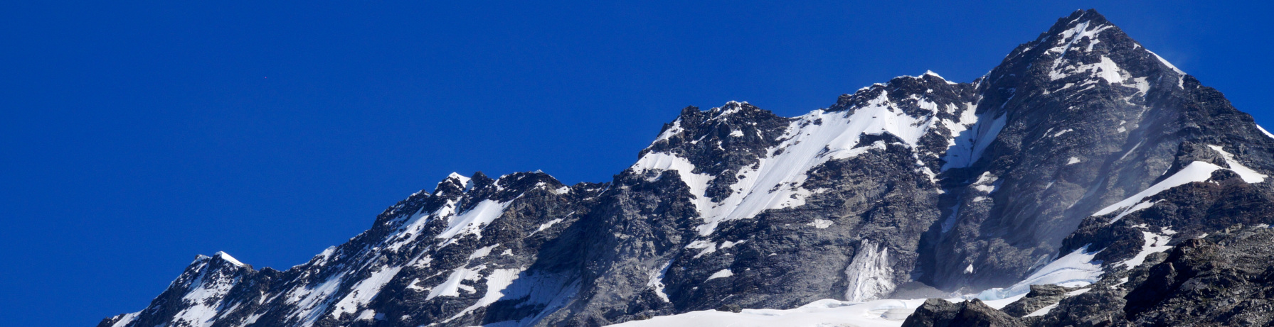
Snow-covered Mt. Sefton

our mascot, always joining us on our travels :-)


We walk into the beautiful Hooker Valley with the flowing Hooker River in the foreground. It’s also our first view of Mt. Cook on the hike, which is visible the whole second half of the hike.
The Aoraki/Mount Cook National Park is a beautiful rugged landscape, with 19 peaks over 3,000 metres including New Zealand's highest mountain, Aoraki/Mount Cook. And it doesn't matter in which direction I look, into the valley, back, left or right, the landscape is stunning in every direction! The highlight for me during this hike are definitely the views! Towering snowy mountains on both sides of a wide lush valley; it is almost like walking in a postcard.


Taking photos from the bridge
And of course I try to take some photos of this postcard-perfect landscape. One good spot to do so is on the second suspenstion bridge; the Hooker Bluff Bridge, where we once more cross the Hooker River.
The bridge is around halfway point, so 2,5 kilometers from the start of the hike. It will take you about 40 to 45 minutes to reach this point; all depending of course on how many stops you take on our way. And uhhhm, I guess it took me far more time than these 45 minutes! ;-) I didn't really keep an eye on the clock, but I stopped often to take in the views; so without a doubt it took me far longer than the estimated hiking time.
This second bridge is perfectly located, looking directly towards the snowy mountains when you are crossing it. The snow on the top of the mountain was piled in places in enormous mounds, desperately clinging on to the steep mountain side. And in the quiet of the valley, we several times heard the sound of thunderous crashing ice coming down from the mountain.

The second suspenstion bridge: the Hooker Bluff Bridge

The beautiful Hooker Valley and its meadow filled with alpine tussock grass.


The area widens, and in front of us the valley is filled with tussock (grass), while we walk on a very long boardwalk above the swampy vegetation. We are now on the final stretch of the walk towards Lake Hooker. The valley is quite open and views of Mount Cook from here are starting to get better and better.


At 3.7 kilometers from the start, a footbridge crosses Stocking Stream.

This hike is a very popular one, and for a good reason. I read that around 70,000 people walk this track each year. I was here out of season, when autumn was approaching fast, and I also started relatively early during the day. And I actually didn't find it that overcrowded during my hike. Another tip that I read to avoid the crowds is to wait untill the end of the day and spend sunset at the lake. Quite a good suggestion I think! Seeing the sunset at Lake Hooker with the impressive Mount Cook towering high against a red sky, must be a fantastic sight! Don't forget your torchlight if you go for this option, as it will be dark on the track for your retun hike.


Here’s the 3rd and final swing bridge over the Hooker River – the Upper Hooker Bridge.

The final stretch of the walk climbs up, phew! But it is worth it, as at the end of the trail we are treated of wonderful views over the Hooker Valley Lake and behind it Mount Cook, or 'Aoraki' as the Maori's call it which means "cloud piercer".
The Hooker Lake is a glacier terminal lake, complete with floating icebergs. And although I had read about the icebergs, I never actually thought that there would be any this late in the season. But to my delight and surprise, there were!
In the photo above you can also see that we not exactly alone in this spot, but at the same time it wasn't too bad. Quite a few people were lingering around, just enjoying being here, surrounded by this impressive landscape.


The icebergs can be seen during the summer months, as during this time of the year they break loose from the Hooker Glacier. I can warmly recommend taking the short path down from the lookout point to Hooker Lake’s rocky shore below. From here you will have a good vantage point from which to check out the different floating icebergs. I guess it is a bit of luck how many icebergs will be on the lake during your visit. But I felt happy to see at least a few of them. The icebergs slowly drift from the terminus of Hooker Glacier at the northern end of the lake south until close to the shore. The lake's water temperature is typically lower than 2 °C.

The shore of Hooker Lake is an amazing place to spend some time. We packed some lunch, and ate it here in leasure before hiking back. There were plenty of spots to sit down on the rocks, and what better view to wish for for a leasurely picknick :-)
The lookout point at the end of the track is the closest any walking track comes to Aoraki / Mount Cook, and has completely unobstructed views of the highest mountain in New Zealand. It is difficult to capture Mount Cook from the Hooker Valley Track however, because the sun is almost always shining right in your face during midday hours when the valley is lit. And well, unfortunately that happened to me as well! But I tried to make the best of it (photo above)
Thid spot also gives time for thought about the ongoing climate change and its effect onto our planet. Hooker Lake is a proglacial lake that started to form in the late 1970s by the recent retreat of the Hooker Glacier. Hooker Lake's length has doubled between 1990 and 2013 from 1.2 kilometres to 2.3 kilometres, retreating by over 50 metres per year. The lake is expected to grow in length by another 4 kilometres as Hooker Glacier retreats further up the valley until the glacier's retreat will have reached the point where the glacier bed is higher than the lake's water level.

It is time to turn back and retrace our steps back to the beginning of the hike. Although the return hike take the exact same route, we saw the valley from a different perspective, now with views down the valley and across to Sealy Range instead. And that actually made me enjoy the hike back just as much as the way towards the Hooker Lake. Below are some impressions of the return hike.


Even though this is the most popular trail in Mt. Cook/Aoraki National Park, don't let the crowds turn you off from this track! The suspension bridges, glacier lakes, and above all; the spectacular views of the snowy peaks surrounding me, made it one of my favorite easy hikes that I have done.
Simone & Åke, February 2017, Hooker Valley, South Island, New Zealand

It would be great to hear from you!
You can reach me by sending me an Email.
Or leave a comment / reaction in the box below.
You can also follow me on Facebook: Sim1 Travels Blog
:-) Simone